You are here: Home > Network List > TA - USArray Transportable Network (new EarthScope stations) Stations List
> Station L44A Lake County Forest Preserve, Grayslake, IL, USA > Earthquake Result Viewer
L44A Lake County Forest Preserve, Grayslake, IL, USA - Earthquake Result Viewer
| Earthquake location: |
Northern Mid-Atlantic Ridge |
| Earthquake latitude/longitude: |
10.7/-42.6 |
| Earthquake time(UTC): |
2013/06/24 (175) 22:04:13 GMT |
| Earthquake Depth: |
10 km |
| Earthquake Magnitude: |
6.5 MW, 6.1 MB, 6.3 MS, 6.6 MW |
| Earthquake Catalog/Contributor: |
NEIC PDE/NEIC PDE-W |
|
| Network: |
TA USArray Transportable Network (new EarthScope stations) |
| Station: |
L44A Lake County Forest Preserve, Grayslake, IL, USA |
| Lat/Lon: |
42.18 N/87.91 W |
| Elevation: |
202 m |
|
| Distance: |
50.4 deg |
| Az: |
316.711 deg |
| Baz: |
114.955 deg |
| Ray Param: |
0.06806733 |
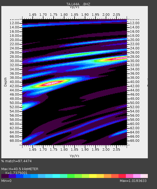
| Estimated Moho Depth: |
40.5 km |
| Estimated Crust Vp/Vs: |
1.74 |
| Assumed Crust Vp: |
6.483 km/s |
| Estimated Crust Vs: |
3.731 km/s |
| Estimated Crust Poisson's Ratio: |
0.25 |
|
| Radial Match: |
97.4474 % |
| Radial Bump: |
364 |
| Transverse Match: |
87.46997 % |
| Transverse Bump: |
400 |
| SOD ConfigId: |
512894 |
| Insert Time: |
2013-09-15 09:42:40.597 +0000 |
| GWidth: |
2.5 |
| Max Bumps: |
400 |
| Tol: |
0.001 |
|
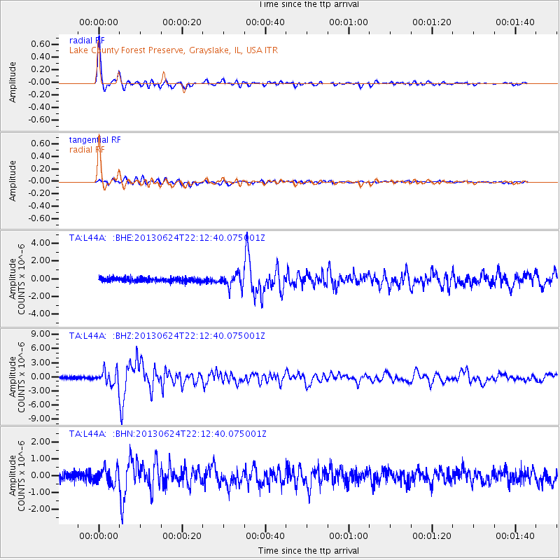
Signal To Noise
| Channel | StoN | STA | LTA |
| TA:L44A: :BHZ:20130624T22:12:40.075001Z | 8.772207 | 1.5159826E-6 | 1.7281656E-7 |
| TA:L44A: :BHN:20130624T22:12:40.075001Z | 1.9508147 | 4.6863104E-7 | 2.4022324E-7 |
| TA:L44A: :BHE:20130624T22:12:40.075001Z | 3.2138288 | 7.7562197E-7 | 2.413389E-7 |
| Arrivals |
| Ps | 4.9 SECOND |
| PpPs | 16 SECOND |
| PsPs/PpSs | 21 SECOND |


