You are here: Home > Network List > TA - USArray Transportable Network (new EarthScope stations) Stations List
> Station L49A Milan, MI, USA > Earthquake Result Viewer
L49A Milan, MI, USA - Earthquake Result Viewer

| Earthquake location: |
Northern Mid-Atlantic Ridge |
| Earthquake latitude/longitude: |
10.7/-42.6 |
| Earthquake time(UTC): |
2013/06/24 (175) 22:04:13 GMT |
| Earthquake Depth: |
10 km |
| Earthquake Magnitude: |
6.5 MW, 6.1 MB, 6.3 MS, 6.6 MW |
| Earthquake Catalog/Contributor: |
NEIC PDE/NEIC PDE-W |
|
| Network: |
TA USArray Transportable Network (new EarthScope stations) |
| Station: |
L49A Milan, MI, USA |
| Lat/Lon: |
42.11 N/83.77 W |
| Elevation: |
230 m |
|
| Distance: |
47.6 deg |
| Az: |
318.477 deg |
| Baz: |
118.885 deg |
| Ray Param: |
0.069857776 |
| Estimated Moho Depth: |
56.25 km |
| Estimated Crust Vp/Vs: |
1.66 |
| Assumed Crust Vp: |
6.483 km/s |
| Estimated Crust Vs: |
3.899 km/s |
| Estimated Crust Poisson's Ratio: |
0.22 |
|
| Radial Match: |
96.0784 % |
| Radial Bump: |
271 |
| Transverse Match: |
83.811935 % |
| Transverse Bump: |
400 |
| SOD ConfigId: |
512894 |
| Insert Time: |
2013-09-15 09:42:51.421 +0000 |
| GWidth: |
2.5 |
| Max Bumps: |
400 |
| Tol: |
0.001 |
|
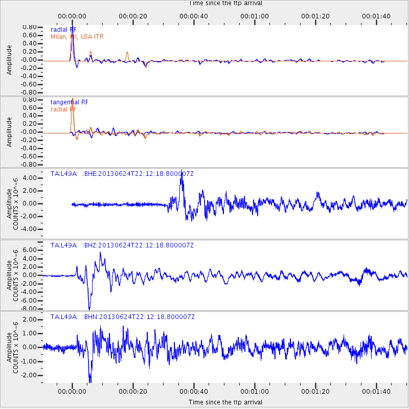
Signal To Noise
| Channel | StoN | STA | LTA |
| TA:L49A: :BHZ:20130624T22:12:18.800007Z | 14.970996 | 9.887839E-7 | 6.604664E-8 |
| TA:L49A: :BHN:20130624T22:12:18.800007Z | 2.5584016 | 2.8997312E-7 | 1.13341514E-7 |
| TA:L49A: :BHE:20130624T22:12:18.800007Z | 5.681258 | 5.742592E-7 | 1.01079586E-7 |
| Arrivals |
| Ps | 6.1 SECOND |
| PpPs | 22 SECOND |
| PsPs/PpSs | 28 SECOND |


