You are here: Home > Network List > TA - USArray Transportable Network (new EarthScope stations) Stations List
> Station L55A Hinsdale, NY, USA > Earthquake Result Viewer
L55A Hinsdale, NY, USA - Earthquake Result Viewer
| Earthquake location: |
Northern Mid-Atlantic Ridge |
| Earthquake latitude/longitude: |
10.7/-42.6 |
| Earthquake time(UTC): |
2013/06/24 (175) 22:04:13 GMT |
| Earthquake Depth: |
10 km |
| Earthquake Magnitude: |
6.5 MW, 6.1 MB, 6.3 MS, 6.6 MW |
| Earthquake Catalog/Contributor: |
NEIC PDE/NEIC PDE-W |
|
| Network: |
TA USArray Transportable Network (new EarthScope stations) |
| Station: |
L55A Hinsdale, NY, USA |
| Lat/Lon: |
42.18 N/78.44 W |
| Elevation: |
633 m |
|
| Distance: |
44.3 deg |
| Az: |
321.462 deg |
| Baz: |
124.525 deg |
| Ray Param: |
0.07199549 |
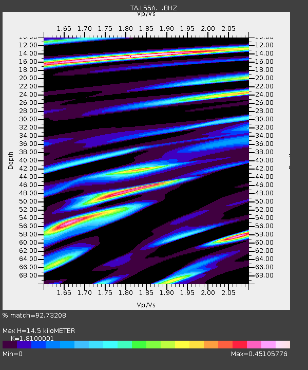
| Estimated Moho Depth: |
14.5 km |
| Estimated Crust Vp/Vs: |
1.81 |
| Assumed Crust Vp: |
6.419 km/s |
| Estimated Crust Vs: |
3.547 km/s |
| Estimated Crust Poisson's Ratio: |
0.28 |
|
| Radial Match: |
92.73208 % |
| Radial Bump: |
392 |
| Transverse Match: |
78.29536 % |
| Transverse Bump: |
400 |
| SOD ConfigId: |
512894 |
| Insert Time: |
2013-09-15 09:43:01.335 +0000 |
| GWidth: |
2.5 |
| Max Bumps: |
400 |
| Tol: |
0.001 |
|

Signal To Noise
| Channel | StoN | STA | LTA |
| TA:L55A: :BHZ:20130624T22:11:52.550007Z | 10.328687 | 9.821761E-7 | 9.5092055E-8 |
| TA:L55A: :BHN:20130624T22:11:52.550007Z | 3.4801943 | 2.6117664E-7 | 7.5046565E-8 |
| TA:L55A: :BHE:20130624T22:11:52.550007Z | 6.148517 | 4.4555787E-7 | 7.246591E-8 |
| Arrivals |
| Ps | 1.9 SECOND |
| PpPs | 6.0 SECOND |
| PsPs/PpSs | 7.9 SECOND |


