You are here: Home > Network List > TA - USArray Transportable Network (new EarthScope stations) Stations List
> Station M45A Boilermakers Shaker, Crown Point, IN, USA > Earthquake Result Viewer
M45A Boilermakers Shaker, Crown Point, IN, USA - Earthquake Result Viewer

| Earthquake location: |
Northern Mid-Atlantic Ridge |
| Earthquake latitude/longitude: |
10.7/-42.6 |
| Earthquake time(UTC): |
2013/06/24 (175) 22:04:13 GMT |
| Earthquake Depth: |
10 km |
| Earthquake Magnitude: |
6.5 MW, 6.1 MB, 6.3 MS, 6.6 MW |
| Earthquake Catalog/Contributor: |
NEIC PDE/NEIC PDE-W |
|
| Network: |
TA USArray Transportable Network (new EarthScope stations) |
| Station: |
M45A Boilermakers Shaker, Crown Point, IN, USA |
| Lat/Lon: |
41.39 N/87.25 W |
| Elevation: |
216 m |
|
| Distance: |
49.6 deg |
| Az: |
316.05 deg |
| Baz: |
114.969 deg |
| Ray Param: |
0.06857084 |
| Estimated Moho Depth: |
43.75 km |
| Estimated Crust Vp/Vs: |
1.82 |
| Assumed Crust Vp: |
6.498 km/s |
| Estimated Crust Vs: |
3.575 km/s |
| Estimated Crust Poisson's Ratio: |
0.28 |
|
| Radial Match: |
96.58695 % |
| Radial Bump: |
291 |
| Transverse Match: |
80.65373 % |
| Transverse Bump: |
400 |
| SOD ConfigId: |
512894 |
| Insert Time: |
2013-09-15 09:43:18.158 +0000 |
| GWidth: |
2.5 |
| Max Bumps: |
400 |
| Tol: |
0.001 |
|
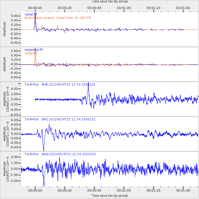
Signal To Noise
| Channel | StoN | STA | LTA |
| TA:M45A: :BHZ:20130624T22:12:34.150013Z | 11.050771 | 1.4559176E-6 | 1.3174805E-7 |
| TA:M45A: :BHN:20130624T22:12:34.150013Z | 1.4143847 | 2.7076484E-7 | 1.9143648E-7 |
| TA:M45A: :BHE:20130624T22:12:34.150013Z | 5.0581007 | 7.66424E-7 | 1.5152408E-7 |
| Arrivals |
| Ps | 5.8 SECOND |
| PpPs | 18 SECOND |
| PsPs/PpSs | 24 SECOND |


