You are here: Home > Network List > TA - USArray Transportable Network (new EarthScope stations) Stations List
> Station N46A Monticello, IN, USA > Earthquake Result Viewer
N46A Monticello, IN, USA - Earthquake Result Viewer
| Earthquake location: |
Northern Mid-Atlantic Ridge |
| Earthquake latitude/longitude: |
10.7/-42.6 |
| Earthquake time(UTC): |
2013/06/24 (175) 22:04:13 GMT |
| Earthquake Depth: |
10 km |
| Earthquake Magnitude: |
6.5 MW, 6.1 MB, 6.3 MS, 6.6 MW |
| Earthquake Catalog/Contributor: |
NEIC PDE/NEIC PDE-W |
|
| Network: |
TA USArray Transportable Network (new EarthScope stations) |
| Station: |
N46A Monticello, IN, USA |
| Lat/Lon: |
40.89 N/86.74 W |
| Elevation: |
209 m |
|
| Distance: |
49.1 deg |
| Az: |
315.678 deg |
| Baz: |
115.065 deg |
| Ray Param: |
0.06893231 |
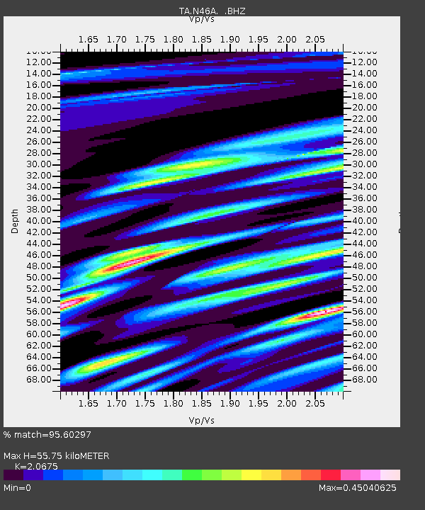
| Estimated Moho Depth: |
55.75 km |
| Estimated Crust Vp/Vs: |
2.07 |
| Assumed Crust Vp: |
6.498 km/s |
| Estimated Crust Vs: |
3.143 km/s |
| Estimated Crust Poisson's Ratio: |
0.35 |
|
| Radial Match: |
95.60297 % |
| Radial Bump: |
400 |
| Transverse Match: |
78.03571 % |
| Transverse Bump: |
400 |
| SOD ConfigId: |
512894 |
| Insert Time: |
2013-09-15 09:44:23.932 +0000 |
| GWidth: |
2.5 |
| Max Bumps: |
400 |
| Tol: |
0.001 |
|
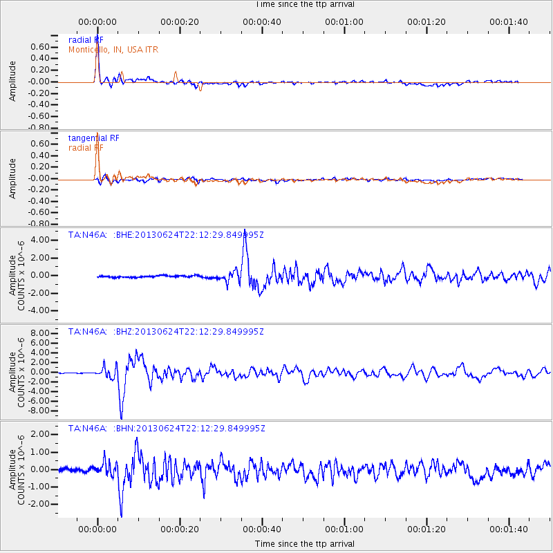
Signal To Noise
| Channel | StoN | STA | LTA |
| TA:N46A: :BHZ:20130624T22:12:29.849995Z | 20.015352 | 1.1018764E-6 | 5.505156E-8 |
| TA:N46A: :BHN:20130624T22:12:29.849995Z | 4.3176384 | 3.729128E-7 | 8.636963E-8 |
| TA:N46A: :BHE:20130624T22:12:29.849995Z | 6.182643 | 5.73149E-7 | 9.270292E-8 |
| Arrivals |
| Ps | 9.6 SECOND |
| PpPs | 25 SECOND |
| PsPs/PpSs | 35 SECOND |


