You are here: Home > Network List > TA - USArray Transportable Network (new EarthScope stations) Stations List
> Station N57A Milroy, PA, USA > Earthquake Result Viewer
N57A Milroy, PA, USA - Earthquake Result Viewer
| Earthquake location: |
Northern Mid-Atlantic Ridge |
| Earthquake latitude/longitude: |
10.7/-42.6 |
| Earthquake time(UTC): |
2013/06/24 (175) 22:04:13 GMT |
| Earthquake Depth: |
10 km |
| Earthquake Magnitude: |
6.5 MW, 6.1 MB, 6.3 MS, 6.6 MW |
| Earthquake Catalog/Contributor: |
NEIC PDE/NEIC PDE-W |
|
| Network: |
TA USArray Transportable Network (new EarthScope stations) |
| Station: |
N57A Milroy, PA, USA |
| Lat/Lon: |
40.76 N/77.55 W |
| Elevation: |
306 m |
|
| Distance: |
43.0 deg |
| Az: |
320.301 deg |
| Baz: |
124.269 deg |
| Ray Param: |
0.07286089 |
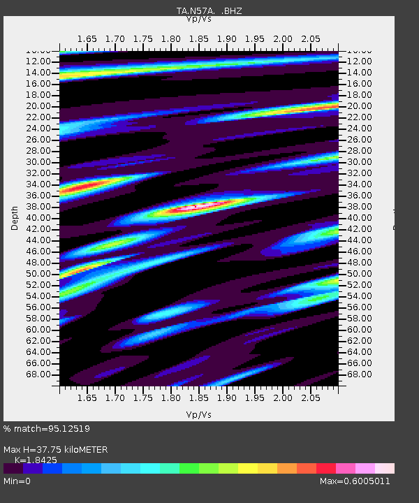
| Estimated Moho Depth: |
37.75 km |
| Estimated Crust Vp/Vs: |
1.84 |
| Assumed Crust Vp: |
6.121 km/s |
| Estimated Crust Vs: |
3.322 km/s |
| Estimated Crust Poisson's Ratio: |
0.29 |
|
| Radial Match: |
95.12519 % |
| Radial Bump: |
331 |
| Transverse Match: |
78.855225 % |
| Transverse Bump: |
400 |
| SOD ConfigId: |
512894 |
| Insert Time: |
2013-09-15 09:44:53.890 +0000 |
| GWidth: |
2.5 |
| Max Bumps: |
400 |
| Tol: |
0.001 |
|
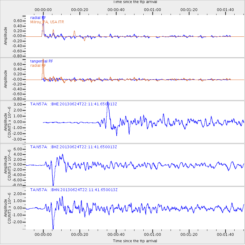
Signal To Noise
| Channel | StoN | STA | LTA |
| TA:N57A: :BHZ:20130624T22:11:41.650013Z | 9.471449 | 7.5076207E-7 | 7.92658E-8 |
| TA:N57A: :BHN:20130624T22:11:41.650013Z | 6.1306424 | 3.3650497E-7 | 5.488902E-8 |
| TA:N57A: :BHE:20130624T22:11:41.650013Z | 9.329666 | 4.3085E-7 | 4.6180645E-8 |
| Arrivals |
| Ps | 5.5 SECOND |
| PpPs | 17 SECOND |
| PsPs/PpSs | 22 SECOND |


