You are here: Home > Network List > TA - USArray Transportable Network (new EarthScope stations) Stations List
> Station O50A Cable, OH, USA > Earthquake Result Viewer
O50A Cable, OH, USA - Earthquake Result Viewer
| Earthquake location: |
Northern Mid-Atlantic Ridge |
| Earthquake latitude/longitude: |
10.7/-42.6 |
| Earthquake time(UTC): |
2013/06/24 (175) 22:04:13 GMT |
| Earthquake Depth: |
10 km |
| Earthquake Magnitude: |
6.5 MW, 6.1 MB, 6.3 MS, 6.6 MW |
| Earthquake Catalog/Contributor: |
NEIC PDE/NEIC PDE-W |
|
| Network: |
TA USArray Transportable Network (new EarthScope stations) |
| Station: |
O50A Cable, OH, USA |
| Lat/Lon: |
40.15 N/83.62 W |
| Elevation: |
399 m |
|
| Distance: |
46.6 deg |
| Az: |
316.191 deg |
| Baz: |
117.425 deg |
| Ray Param: |
0.07053115 |
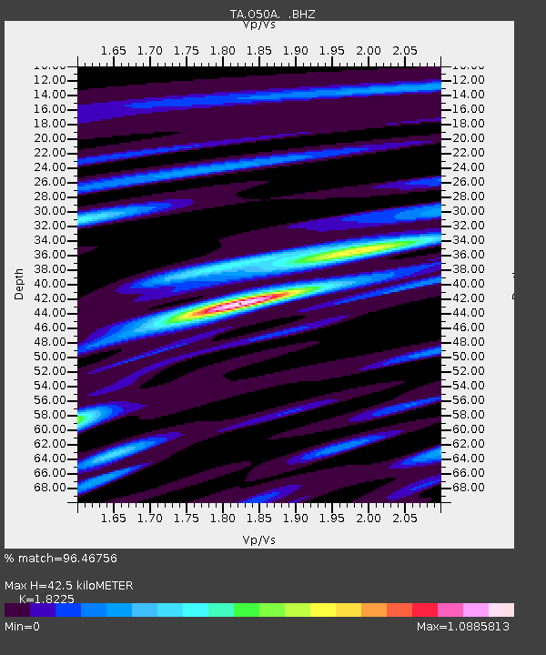
| Estimated Moho Depth: |
42.5 km |
| Estimated Crust Vp/Vs: |
1.82 |
| Assumed Crust Vp: |
6.498 km/s |
| Estimated Crust Vs: |
3.565 km/s |
| Estimated Crust Poisson's Ratio: |
0.28 |
|
| Radial Match: |
96.46756 % |
| Radial Bump: |
300 |
| Transverse Match: |
85.418594 % |
| Transverse Bump: |
400 |
| SOD ConfigId: |
512894 |
| Insert Time: |
2013-09-15 09:45:23.444 +0000 |
| GWidth: |
2.5 |
| Max Bumps: |
400 |
| Tol: |
0.001 |
|
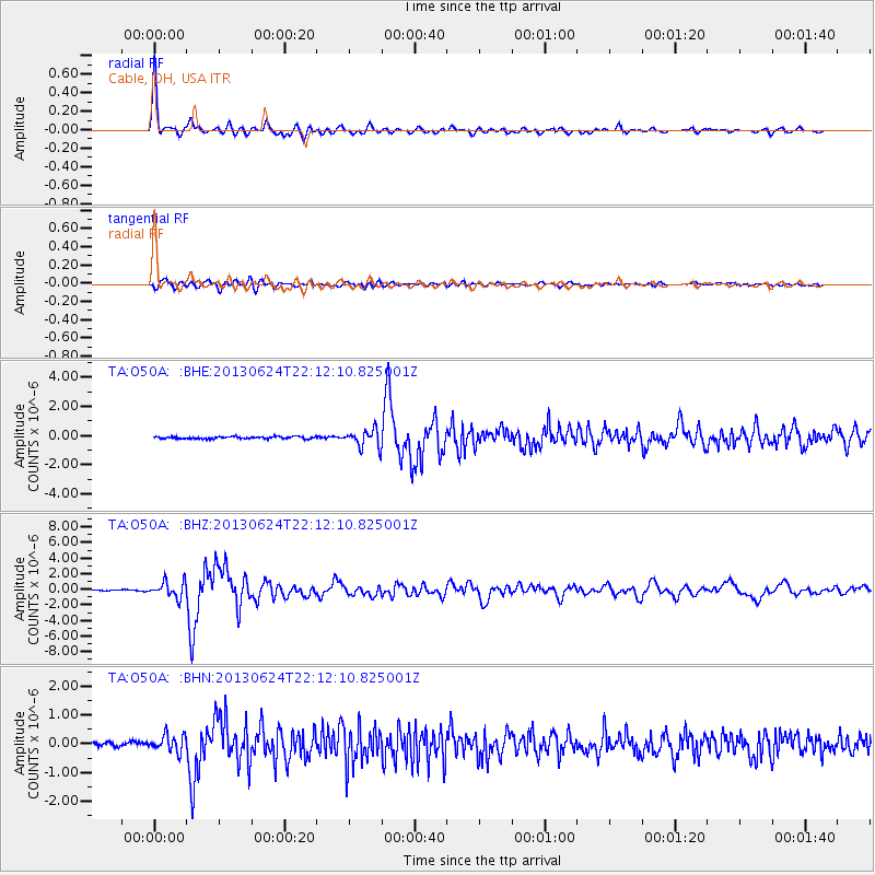
Signal To Noise
| Channel | StoN | STA | LTA |
| TA:O50A: :BHZ:20130624T22:12:10.825001Z | 13.581923 | 1.0328868E-6 | 7.6048636E-8 |
| TA:O50A: :BHN:20130624T22:12:10.825001Z | 4.6403775 | 2.9410052E-7 | 6.337858E-8 |
| TA:O50A: :BHE:20130624T22:12:10.825001Z | 8.54919 | 6.018448E-7 | 7.039788E-8 |
| Arrivals |
| Ps | 5.7 SECOND |
| PpPs | 17 SECOND |
| PsPs/PpSs | 23 SECOND |


