You are here: Home > Network List > TA - USArray Transportable Network (new EarthScope stations) Stations List
> Station O60A Telford, PA, USA > Earthquake Result Viewer
O60A Telford, PA, USA - Earthquake Result Viewer
| Earthquake location: |
Northern Mid-Atlantic Ridge |
| Earthquake latitude/longitude: |
10.7/-42.6 |
| Earthquake time(UTC): |
2013/06/24 (175) 22:04:13 GMT |
| Earthquake Depth: |
10 km |
| Earthquake Magnitude: |
6.5 MW, 6.1 MB, 6.3 MS, 6.6 MW |
| Earthquake Catalog/Contributor: |
NEIC PDE/NEIC PDE-W |
|
| Network: |
TA USArray Transportable Network (new EarthScope stations) |
| Station: |
O60A Telford, PA, USA |
| Lat/Lon: |
40.32 N/75.40 W |
| Elevation: |
70 m |
|
| Distance: |
41.4 deg |
| Az: |
321.177 deg |
| Baz: |
126.308 deg |
| Ray Param: |
0.07383673 |
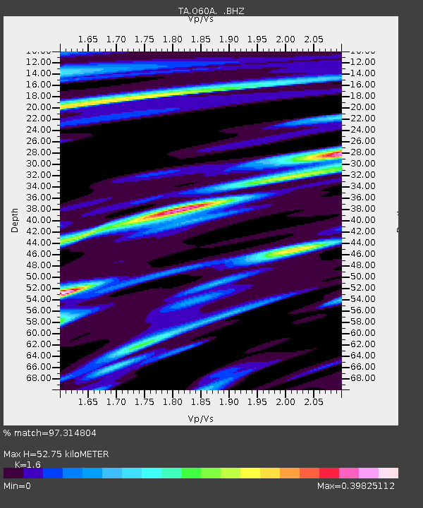
| Estimated Moho Depth: |
52.75 km |
| Estimated Crust Vp/Vs: |
1.60 |
| Assumed Crust Vp: |
6.283 km/s |
| Estimated Crust Vs: |
3.927 km/s |
| Estimated Crust Poisson's Ratio: |
0.18 |
|
| Radial Match: |
97.314804 % |
| Radial Bump: |
223 |
| Transverse Match: |
92.412254 % |
| Transverse Bump: |
400 |
| SOD ConfigId: |
512894 |
| Insert Time: |
2013-09-15 09:45:53.102 +0000 |
| GWidth: |
2.5 |
| Max Bumps: |
400 |
| Tol: |
0.001 |
|
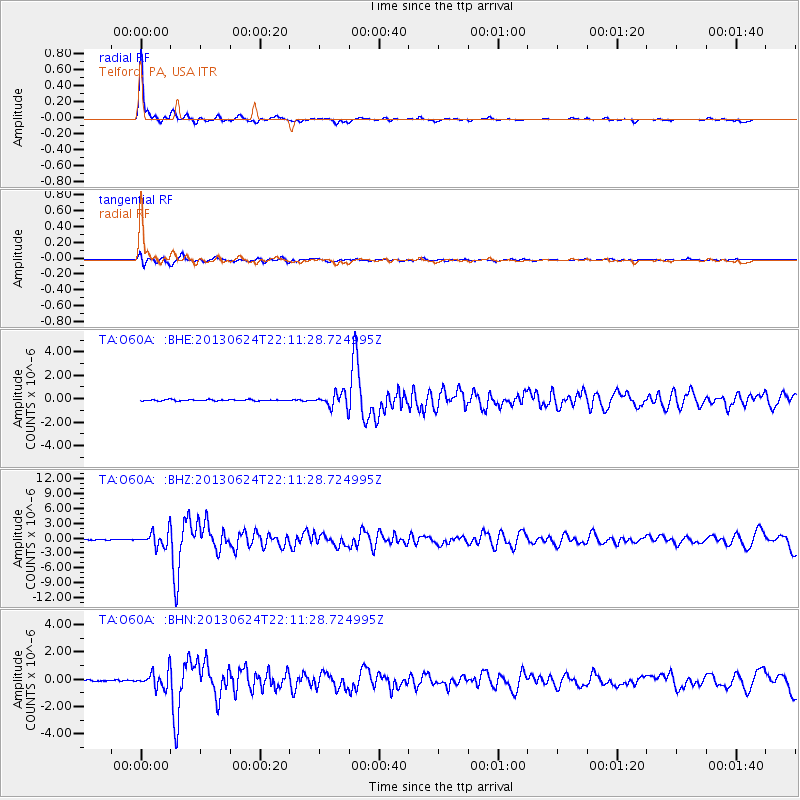
Signal To Noise
| Channel | StoN | STA | LTA |
| TA:O60A: :BHZ:20130624T22:11:28.724995Z | 16.41935 | 1.5218144E-6 | 9.268421E-8 |
| TA:O60A: :BHN:20130624T22:11:28.724995Z | 9.122179 | 6.151963E-7 | 6.743962E-8 |
| TA:O60A: :BHE:20130624T22:11:28.724995Z | 10.9464445 | 5.8593537E-7 | 5.3527458E-8 |
| Arrivals |
| Ps | 5.4 SECOND |
| PpPs | 20 SECOND |
| PsPs/PpSs | 26 SECOND |


