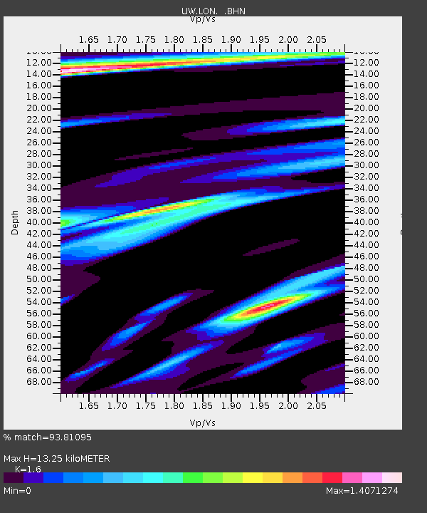
LON Longmire (broad-band and DWWSSN) - Earthquake Result Viewer
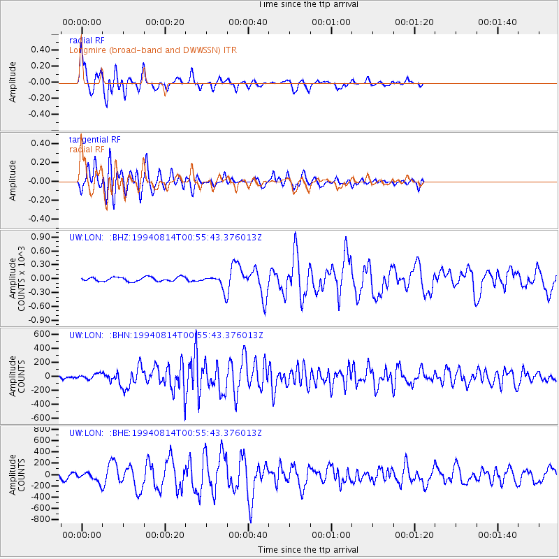
Earthquake location: East Of Kuril Islands
Earthquake latitude/longitude: 44.7/150.1
Earthquake time(UTC): 1994/08/14 (226) 00:46:22 GMT
Earthquake Depth: 33 km
Earthquake Magnitude: 5.9 MB, 5.8 MS, 5.4 UNKNOWN, 6.1 MW
Earthquake Catalog/Contributor: WHDF/NEIC
Network: UW Pacific Northwest Regional Seismic Network
Station: LON Longmire (broad-band and DWWSSN)
Lat/Lon: 46.75 N/121.81 W
Elevation: 850 m
Distance: 58.3 deg
Az: 53.858 deg
Baz: 303.052 deg
Ray Param: 0.06286354
Estimated Moho Depth: 13.25 km
Estimated Crust Vp/Vs: 1.60
Assumed Crust Vp: 6.597 km/s
Estimated Crust Vs: 4.123 km/s
Estimated Crust Poisson's Ratio: 0.18
Radial Match: 93.81095 %
Radial Bump: 400
Transverse Match: 86.9648 %
Transverse Bump: 400
SOD ConfigId: 16938
Insert Time: 2010-02-27 04:42:53.768 +0000
GWidth: 2.5
Max Bumps: 400
Tol: 0.001

Signal To Noise

ChannelStoNSTALTA
UW:LON: :BHN:19940814T00:55:43.376013Z1.449928937.942526.168526
UW:LON: :BHE:19940814T00:55:43.376013Z2.169203884.59801538.999573
UW:LON: :BHZ:19940814T00:55:43.376013Z3.648887162.2800144.473843
Arrivals
Ps1.3 SECOND
PpPs4.9 SECOND
PsPs/PpSs6.2 SECOND