You are here: Home > Network List > UW - Pacific Northwest Regional Seismic Network Stations List
> Station LON Longmire (broad-band and DWWSSN) > Earthquake Result Viewer
LON Longmire (broad-band and DWWSSN) - Earthquake Result Viewer
| Earthquake location: |
Santa Cruz Islands |
| Earthquake latitude/longitude: |
-11.5/166.4 |
| Earthquake time(UTC): |
1994/08/22 (234) 17:26:38 GMT |
| Earthquake Depth: |
148 km |
| Earthquake Magnitude: |
6.1 MB, 6.4 UNKNOWN, 6.1 MW |
| Earthquake Catalog/Contributor: |
WHDF/NEIC |
|
| Network: |
UW Pacific Northwest Regional Seismic Network |
| Station: |
LON Longmire (broad-band and DWWSSN) |
| Lat/Lon: |
46.75 N/121.81 W |
| Elevation: |
850 m |
|
| Distance: |
86.2 deg |
| Az: |
40.889 deg |
| Baz: |
248.925 deg |
| Ray Param: |
0.04392157 |
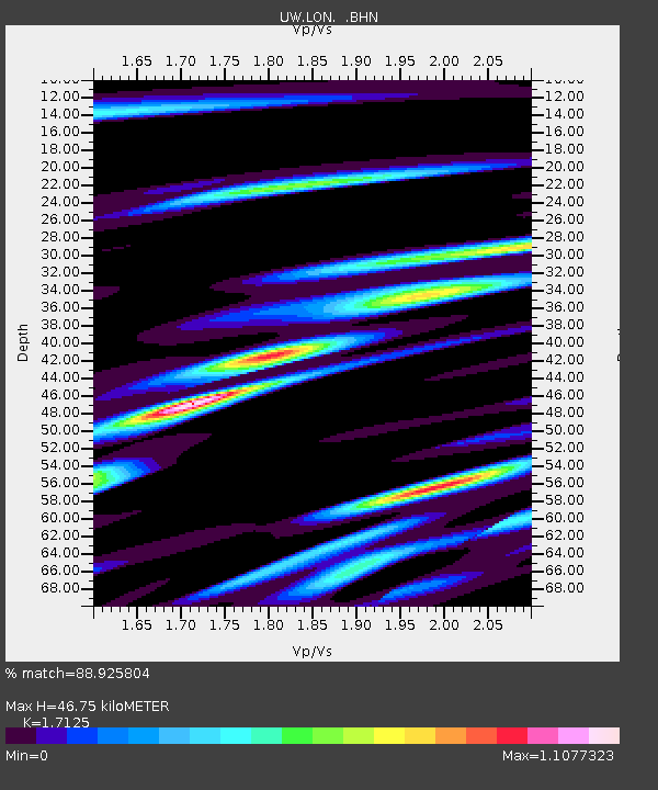
| Estimated Moho Depth: |
46.75 km |
| Estimated Crust Vp/Vs: |
1.71 |
| Assumed Crust Vp: |
6.597 km/s |
| Estimated Crust Vs: |
3.853 km/s |
| Estimated Crust Poisson's Ratio: |
0.24 |
|
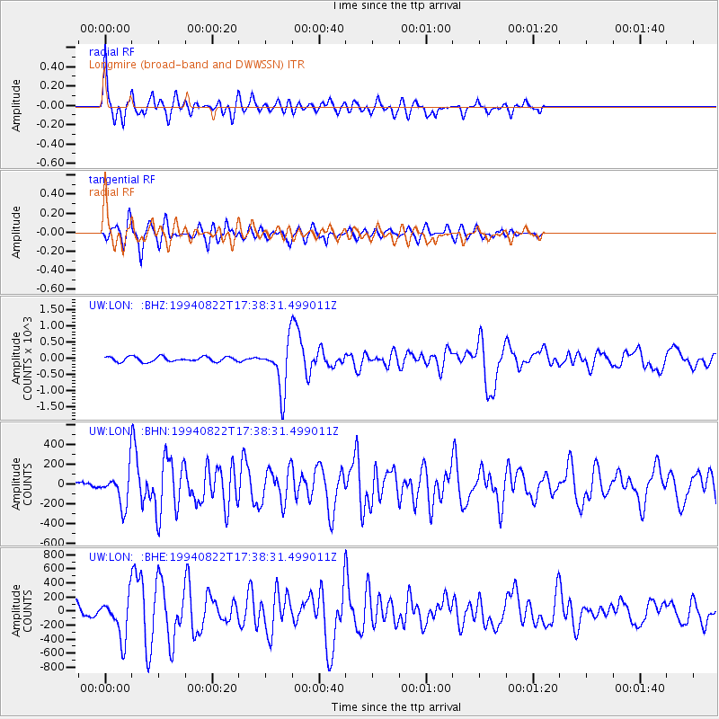
| Radial Match: |
88.925804 % |
| Radial Bump: |
400 |
| Transverse Match: |
75.736565 % |
| Transverse Bump: |
400 |
| SOD ConfigId: |
17000 |
| Insert Time: |
2010-02-27 04:43:00.577 +0000 |
| GWidth: |
2.5 |
| Max Bumps: |
400 |
| Tol: |
0.001 |
|
Signal To Noise
| Channel | StoN | STA | LTA |
| UW:LON: :BHN:19940822T17:38:31.499011Z | 1.9776735 | 171.89023 | 86.915375 |
| UW:LON: :BHE:19940822T17:38:31.499011Z | 4.3000083 | 294.66827 | 68.527374 |
| UW:LON: :BHZ:19940822T17:38:31.499011Z | 9.835388 | 757.2754 | 76.994965 |
| Arrivals |
| Ps | 5.2 SECOND |
| PpPs | 19 SECOND |
| PsPs/PpSs | 24 SECOND |


