You are here: Home > Network List > TA - USArray Transportable Network (new EarthScope stations) Stations List
> Station Q59A Harwood, MD, USA > Earthquake Result Viewer
Q59A Harwood, MD, USA - Earthquake Result Viewer
| Earthquake location: |
Northern Mid-Atlantic Ridge |
| Earthquake latitude/longitude: |
10.7/-42.6 |
| Earthquake time(UTC): |
2013/06/24 (175) 22:04:13 GMT |
| Earthquake Depth: |
10 km |
| Earthquake Magnitude: |
6.5 MW, 6.1 MB, 6.3 MS, 6.6 MW |
| Earthquake Catalog/Contributor: |
NEIC PDE/NEIC PDE-W |
|
| Network: |
TA USArray Transportable Network (new EarthScope stations) |
| Station: |
Q59A Harwood, MD, USA |
| Lat/Lon: |
38.86 N/76.65 W |
| Elevation: |
34 m |
|
| Distance: |
41.3 deg |
| Az: |
318.539 deg |
| Baz: |
123.533 deg |
| Ray Param: |
0.07386124 |
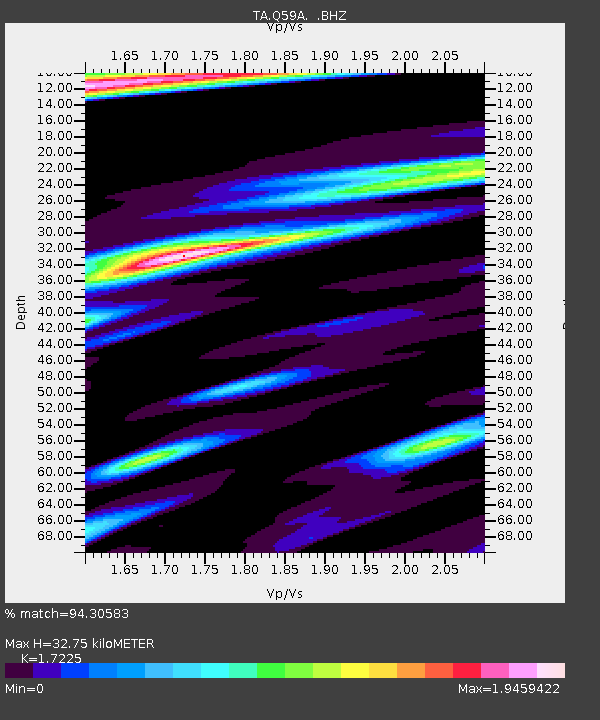
| Estimated Moho Depth: |
32.75 km |
| Estimated Crust Vp/Vs: |
1.72 |
| Assumed Crust Vp: |
6.419 km/s |
| Estimated Crust Vs: |
3.727 km/s |
| Estimated Crust Poisson's Ratio: |
0.25 |
|
| Radial Match: |
94.30583 % |
| Radial Bump: |
380 |
| Transverse Match: |
84.80786 % |
| Transverse Bump: |
400 |
| SOD ConfigId: |
512894 |
| Insert Time: |
2013-09-15 09:47:26.248 +0000 |
| GWidth: |
2.5 |
| Max Bumps: |
400 |
| Tol: |
0.001 |
|

Signal To Noise
| Channel | StoN | STA | LTA |
| TA:Q59A: :BHZ:20130624T22:11:28.400013Z | 5.9989033 | 1.4715195E-6 | 2.4529808E-7 |
| TA:Q59A: :BHN:20130624T22:11:28.400013Z | 1.7329946 | 5.970953E-7 | 3.445454E-7 |
| TA:Q59A: :BHE:20130624T22:11:28.400013Z | 2.115917 | 7.196682E-7 | 3.401212E-7 |
| Arrivals |
| Ps | 4.0 SECOND |
| PpPs | 13 SECOND |
| PsPs/PpSs | 17 SECOND |


