You are here: Home > Network List > TA - USArray Transportable Network (new EarthScope stations) Stations List
> Station R59A King George, VA, USA > Earthquake Result Viewer
R59A King George, VA, USA - Earthquake Result Viewer
| Earthquake location: |
Northern Mid-Atlantic Ridge |
| Earthquake latitude/longitude: |
10.7/-42.6 |
| Earthquake time(UTC): |
2013/06/24 (175) 22:04:13 GMT |
| Earthquake Depth: |
10 km |
| Earthquake Magnitude: |
6.5 MW, 6.1 MB, 6.3 MS, 6.6 MW |
| Earthquake Catalog/Contributor: |
NEIC PDE/NEIC PDE-W |
|
| Network: |
TA USArray Transportable Network (new EarthScope stations) |
| Station: |
R59A King George, VA, USA |
| Lat/Lon: |
38.20 N/77.12 W |
| Elevation: |
35 m |
|
| Distance: |
41.3 deg |
| Az: |
317.397 deg |
| Baz: |
122.389 deg |
| Ray Param: |
0.073897205 |
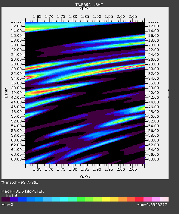
| Estimated Moho Depth: |
33.5 km |
| Estimated Crust Vp/Vs: |
1.60 |
| Assumed Crust Vp: |
6.419 km/s |
| Estimated Crust Vs: |
4.012 km/s |
| Estimated Crust Poisson's Ratio: |
0.18 |
|
| Radial Match: |
93.77361 % |
| Radial Bump: |
400 |
| Transverse Match: |
80.43958 % |
| Transverse Bump: |
400 |
| SOD ConfigId: |
512894 |
| Insert Time: |
2013-09-15 09:48:14.190 +0000 |
| GWidth: |
2.5 |
| Max Bumps: |
400 |
| Tol: |
0.001 |
|

Signal To Noise
| Channel | StoN | STA | LTA |
| TA:R59A: :BHZ:20130624T22:11:27.925007Z | 5.967159 | 1.4374051E-6 | 2.40886E-7 |
| TA:R59A: :BHN:20130624T22:11:27.925007Z | 1.4719144 | 4.423474E-7 | 3.0052522E-7 |
| TA:R59A: :BHE:20130624T22:11:27.925007Z | 2.00943 | 7.0979746E-7 | 3.5323325E-7 |
| Arrivals |
| Ps | 3.4 SECOND |
| PpPs | 13 SECOND |
| PsPs/PpSs | 16 SECOND |


