You are here: Home > Network List > TA - USArray Transportable Network (new EarthScope stations) Stations List
> Station R60A Leonardtown, MD, USA > Earthquake Result Viewer
R60A Leonardtown, MD, USA - Earthquake Result Viewer

| Earthquake location: |
Northern Mid-Atlantic Ridge |
| Earthquake latitude/longitude: |
10.7/-42.6 |
| Earthquake time(UTC): |
2013/06/24 (175) 22:04:13 GMT |
| Earthquake Depth: |
10 km |
| Earthquake Magnitude: |
6.5 MW, 6.1 MB, 6.3 MS, 6.6 MW |
| Earthquake Catalog/Contributor: |
NEIC PDE/NEIC PDE-W |
|
| Network: |
TA USArray Transportable Network (new EarthScope stations) |
| Station: |
R60A Leonardtown, MD, USA |
| Lat/Lon: |
38.26 N/76.58 W |
| Elevation: |
33 m |
|
| Distance: |
41.0 deg |
| Az: |
317.825 deg |
| Baz: |
123.042 deg |
| Ray Param: |
0.074095815 |
| Estimated Moho Depth: |
14.75 km |
| Estimated Crust Vp/Vs: |
1.60 |
| Assumed Crust Vp: |
6.419 km/s |
| Estimated Crust Vs: |
4.012 km/s |
| Estimated Crust Poisson's Ratio: |
0.18 |
|
| Radial Match: |
85.909706 % |
| Radial Bump: |
400 |
| Transverse Match: |
78.41845 % |
| Transverse Bump: |
400 |
| SOD ConfigId: |
512894 |
| Insert Time: |
2013-09-15 09:48:19.902 +0000 |
| GWidth: |
2.5 |
| Max Bumps: |
400 |
| Tol: |
0.001 |
|
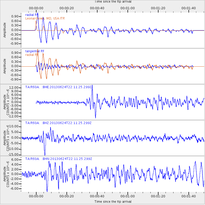
Signal To Noise
| Channel | StoN | STA | LTA |
| TA:R60A: :BHZ:20130624T22:11:25.299Z | 4.1986403 | 2.1929193E-6 | 5.222927E-7 |
| TA:R60A: :BHN:20130624T22:11:25.299Z | 1.1484697 | 5.8599045E-7 | 5.102359E-7 |
| TA:R60A: :BHE:20130624T22:11:25.299Z | 2.4278576 | 1.2231121E-6 | 5.0378253E-7 |
| Arrivals |
| Ps | 1.5 SECOND |
| PpPs | 5.5 SECOND |
| PsPs/PpSs | 7.0 SECOND |


