You are here: Home > Network List > TA - USArray Transportable Network (new EarthScope stations) Stations List
> Station S47A Hartford, KY, USA > Earthquake Result Viewer
S47A Hartford, KY, USA - Earthquake Result Viewer
| Earthquake location: |
Northern Mid-Atlantic Ridge |
| Earthquake latitude/longitude: |
10.7/-42.6 |
| Earthquake time(UTC): |
2013/06/24 (175) 22:04:13 GMT |
| Earthquake Depth: |
10 km |
| Earthquake Magnitude: |
6.5 MW, 6.1 MB, 6.3 MS, 6.6 MW |
| Earthquake Catalog/Contributor: |
NEIC PDE/NEIC PDE-W |
|
| Network: |
TA USArray Transportable Network (new EarthScope stations) |
| Station: |
S47A Hartford, KY, USA |
| Lat/Lon: |
37.59 N/86.88 W |
| Elevation: |
181 m |
|
| Distance: |
47.9 deg |
| Az: |
311.586 deg |
| Baz: |
112.261 deg |
| Ray Param: |
0.069723904 |
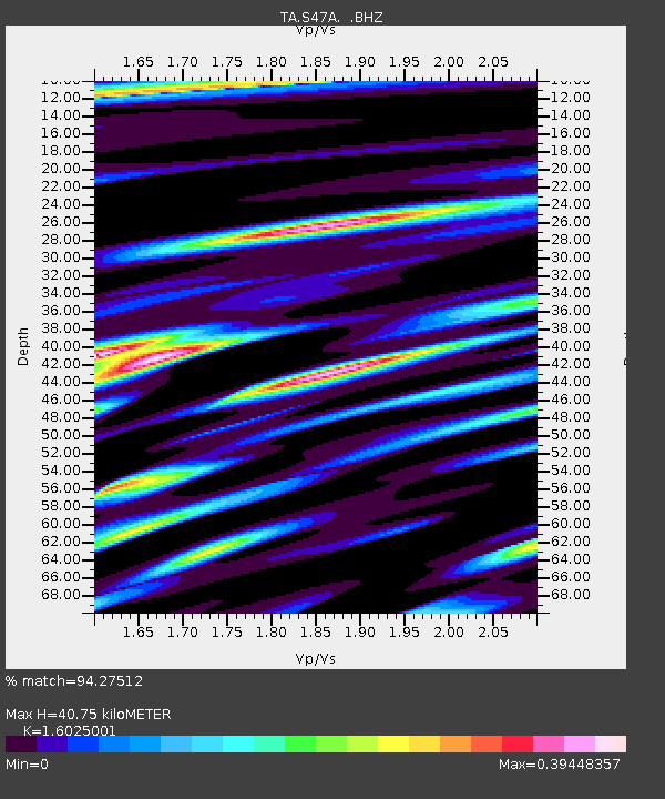
| Estimated Moho Depth: |
40.75 km |
| Estimated Crust Vp/Vs: |
1.60 |
| Assumed Crust Vp: |
6.444 km/s |
| Estimated Crust Vs: |
4.021 km/s |
| Estimated Crust Poisson's Ratio: |
0.18 |
|
| Radial Match: |
94.27512 % |
| Radial Bump: |
316 |
| Transverse Match: |
87.42907 % |
| Transverse Bump: |
400 |
| SOD ConfigId: |
512894 |
| Insert Time: |
2013-09-15 09:48:30.419 +0000 |
| GWidth: |
2.5 |
| Max Bumps: |
400 |
| Tol: |
0.001 |
|
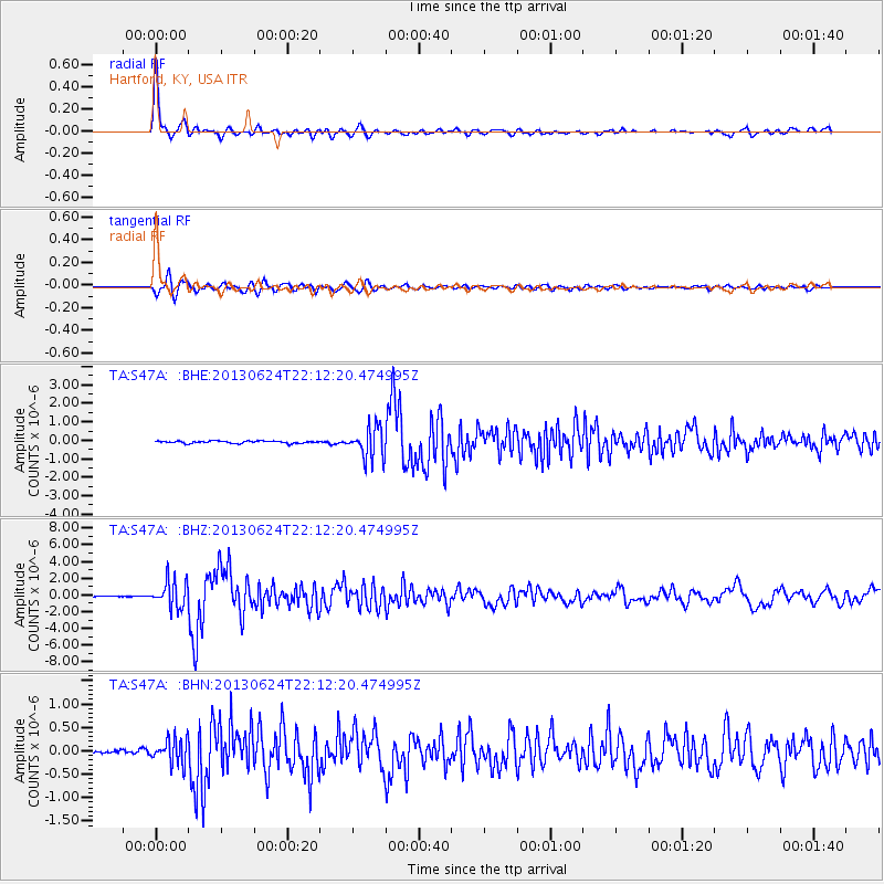
Signal To Noise
| Channel | StoN | STA | LTA |
| TA:S47A: :BHZ:20130624T22:12:20.474995Z | 23.29956 | 1.5788163E-6 | 6.776163E-8 |
| TA:S47A: :BHN:20130624T22:12:20.474995Z | 4.8750873 | 2.630361E-7 | 5.395516E-8 |
| TA:S47A: :BHE:20130624T22:12:20.474995Z | 13.788546 | 8.440728E-7 | 6.121551E-8 |
| Arrivals |
| Ps | 4.1 SECOND |
| PpPs | 15 SECOND |
| PsPs/PpSs | 19 SECOND |


