You are here: Home > Network List > TA - USArray Transportable Network (new EarthScope stations) Stations List
> Station S54A Dingess, Beckley, WV, USA > Earthquake Result Viewer
S54A Dingess, Beckley, WV, USA - Earthquake Result Viewer
| Earthquake location: |
Northern Mid-Atlantic Ridge |
| Earthquake latitude/longitude: |
10.7/-42.6 |
| Earthquake time(UTC): |
2013/06/24 (175) 22:04:13 GMT |
| Earthquake Depth: |
10 km |
| Earthquake Magnitude: |
6.5 MW, 6.1 MB, 6.3 MS, 6.6 MW |
| Earthquake Catalog/Contributor: |
NEIC PDE/NEIC PDE-W |
|
| Network: |
TA USArray Transportable Network (new EarthScope stations) |
| Station: |
S54A Dingess, Beckley, WV, USA |
| Lat/Lon: |
37.80 N/81.31 W |
| Elevation: |
636 m |
|
| Distance: |
43.9 deg |
| Az: |
314.437 deg |
| Baz: |
117.638 deg |
| Ray Param: |
0.07222442 |
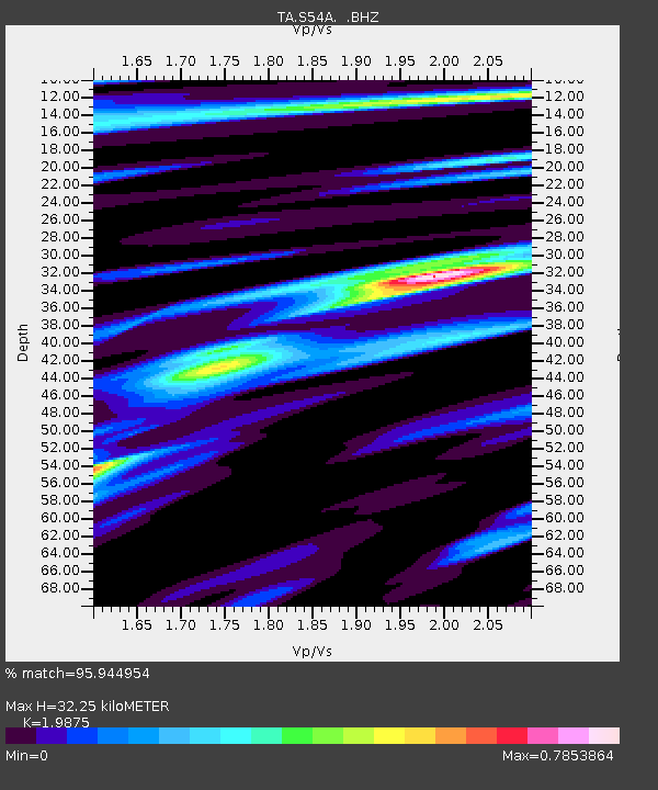
| Estimated Moho Depth: |
32.25 km |
| Estimated Crust Vp/Vs: |
1.99 |
| Assumed Crust Vp: |
6.159 km/s |
| Estimated Crust Vs: |
3.099 km/s |
| Estimated Crust Poisson's Ratio: |
0.33 |
|
| Radial Match: |
95.944954 % |
| Radial Bump: |
335 |
| Transverse Match: |
85.70768 % |
| Transverse Bump: |
400 |
| SOD ConfigId: |
512894 |
| Insert Time: |
2013-09-15 09:48:53.114 +0000 |
| GWidth: |
2.5 |
| Max Bumps: |
400 |
| Tol: |
0.001 |
|
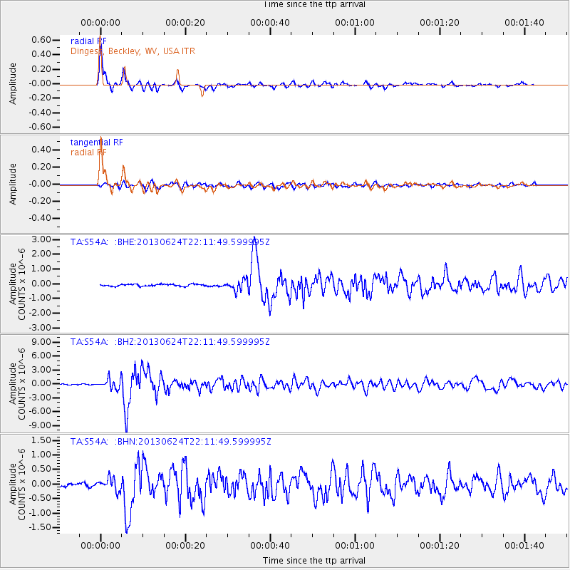
Signal To Noise
| Channel | StoN | STA | LTA |
| TA:S54A: :BHZ:20130624T22:11:49.599995Z | 11.922699 | 1.0606306E-6 | 8.895893E-8 |
| TA:S54A: :BHN:20130624T22:11:49.599995Z | 4.782946 | 2.1554531E-7 | 4.5065388E-8 |
| TA:S54A: :BHE:20130624T22:11:49.599995Z | 5.4016013 | 3.548773E-7 | 6.5698536E-8 |
| Arrivals |
| Ps | 5.5 SECOND |
| PpPs | 15 SECOND |
| PsPs/PpSs | 20 SECOND |


