You are here: Home > Network List > TA - USArray Transportable Network (new EarthScope stations) Stations List
> Station T49A Edmonton, KY, USA > Earthquake Result Viewer
T49A Edmonton, KY, USA - Earthquake Result Viewer

| Earthquake location: |
Northern Mid-Atlantic Ridge |
| Earthquake latitude/longitude: |
10.7/-42.6 |
| Earthquake time(UTC): |
2013/06/24 (175) 22:04:13 GMT |
| Earthquake Depth: |
10 km |
| Earthquake Magnitude: |
6.5 MW, 6.1 MB, 6.3 MS, 6.6 MW |
| Earthquake Catalog/Contributor: |
NEIC PDE/NEIC PDE-W |
|
| Network: |
TA USArray Transportable Network (new EarthScope stations) |
| Station: |
T49A Edmonton, KY, USA |
| Lat/Lon: |
37.10 N/85.53 W |
| Elevation: |
313 m |
|
| Distance: |
46.7 deg |
| Az: |
311.534 deg |
| Baz: |
113.038 deg |
| Ray Param: |
0.070493095 |
| Estimated Moho Depth: |
39.5 km |
| Estimated Crust Vp/Vs: |
1.60 |
| Assumed Crust Vp: |
6.476 km/s |
| Estimated Crust Vs: |
4.047 km/s |
| Estimated Crust Poisson's Ratio: |
0.18 |
|
| Radial Match: |
93.3803 % |
| Radial Bump: |
362 |
| Transverse Match: |
70.96258 % |
| Transverse Bump: |
400 |
| SOD ConfigId: |
512894 |
| Insert Time: |
2013-09-15 09:49:36.122 +0000 |
| GWidth: |
2.5 |
| Max Bumps: |
400 |
| Tol: |
0.001 |
|
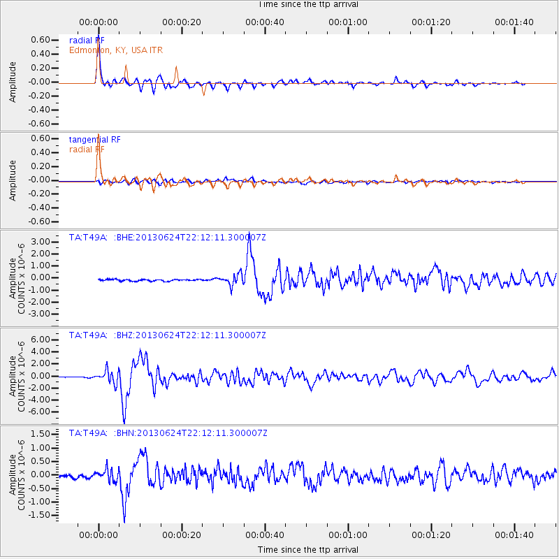
Signal To Noise
| Channel | StoN | STA | LTA |
| TA:T49A: :BHZ:20130624T22:12:11.300007Z | 21.196175 | 1.0398049E-6 | 4.9056254E-8 |
| TA:T49A: :BHN:20130624T22:12:11.300007Z | 4.0522037 | 2.2276282E-7 | 5.4973256E-8 |
| TA:T49A: :BHE:20130624T22:12:11.300007Z | 7.0775695 | 4.5764796E-7 | 6.466174E-8 |
| Arrivals |
| Ps | 3.9 SECOND |
| PpPs | 15 SECOND |
| PsPs/PpSs | 19 SECOND |


