You are here: Home > Network List > TA - USArray Transportable Network (new EarthScope stations) Stations List
> Station T57A Hurt, VA, USA > Earthquake Result Viewer
T57A Hurt, VA, USA - Earthquake Result Viewer
| Earthquake location: |
Northern Mid-Atlantic Ridge |
| Earthquake latitude/longitude: |
10.7/-42.6 |
| Earthquake time(UTC): |
2013/06/24 (175) 22:04:13 GMT |
| Earthquake Depth: |
10 km |
| Earthquake Magnitude: |
6.5 MW, 6.1 MB, 6.3 MS, 6.6 MW |
| Earthquake Catalog/Contributor: |
NEIC PDE/NEIC PDE-W |
|
| Network: |
TA USArray Transportable Network (new EarthScope stations) |
| Station: |
T57A Hurt, VA, USA |
| Lat/Lon: |
37.00 N/79.25 W |
| Elevation: |
230 m |
|
| Distance: |
42.1 deg |
| Az: |
314.544 deg |
| Baz: |
118.96 deg |
| Ray Param: |
0.07335793 |
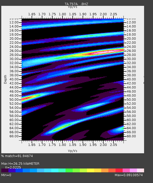
| Estimated Moho Depth: |
26.25 km |
| Estimated Crust Vp/Vs: |
2.02 |
| Assumed Crust Vp: |
6.419 km/s |
| Estimated Crust Vs: |
3.174 km/s |
| Estimated Crust Poisson's Ratio: |
0.34 |
|
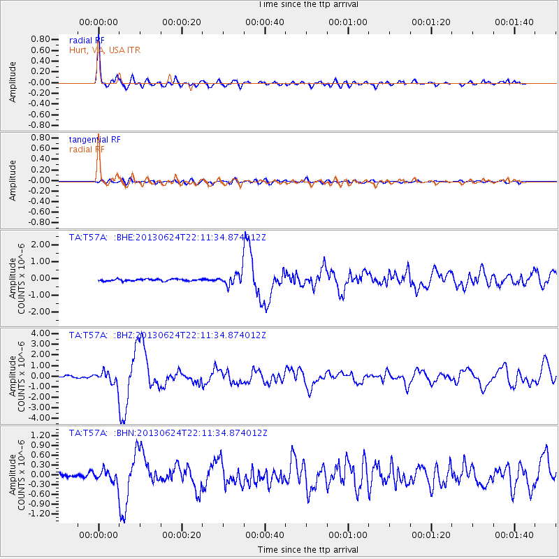
| Radial Match: |
91.94674 % |
| Radial Bump: |
400 |
| Transverse Match: |
58.995747 % |
| Transverse Bump: |
400 |
| SOD ConfigId: |
512894 |
| Insert Time: |
2013-09-15 09:49:59.691 +0000 |
| GWidth: |
2.5 |
| Max Bumps: |
400 |
| Tol: |
0.001 |
|
Signal To Noise
| Channel | StoN | STA | LTA |
| TA:T57A: :BHZ:20130624T22:11:34.874012Z | 6.001512 | 6.182872E-7 | 1.030219E-7 |
| TA:T57A: :BHN:20130624T22:11:34.874012Z | 2.8065832 | 1.8312434E-7 | 6.5248145E-8 |
| TA:T57A: :BHE:20130624T22:11:34.874012Z | 7.0539546 | 3.9398643E-7 | 5.585327E-8 |
| Arrivals |
| Ps | 4.4 SECOND |
| PpPs | 12 SECOND |
| PsPs/PpSs | 16 SECOND |


