You are here: Home > Network List > TA - USArray Transportable Network (new EarthScope stations) Stations List
> Station U46A Springville, TN, USA > Earthquake Result Viewer
U46A Springville, TN, USA - Earthquake Result Viewer

| Earthquake location: |
Northern Mid-Atlantic Ridge |
| Earthquake latitude/longitude: |
10.7/-42.6 |
| Earthquake time(UTC): |
2013/06/24 (175) 22:04:13 GMT |
| Earthquake Depth: |
10 km |
| Earthquake Magnitude: |
6.5 MW, 6.1 MB, 6.3 MS, 6.6 MW |
| Earthquake Catalog/Contributor: |
NEIC PDE/NEIC PDE-W |
|
| Network: |
TA USArray Transportable Network (new EarthScope stations) |
| Station: |
U46A Springville, TN, USA |
| Lat/Lon: |
36.36 N/88.18 W |
| Elevation: |
146 m |
|
| Distance: |
48.4 deg |
| Az: |
309.537 deg |
| Baz: |
110.114 deg |
| Ray Param: |
0.069397576 |
| Estimated Moho Depth: |
46.0 km |
| Estimated Crust Vp/Vs: |
2.00 |
| Assumed Crust Vp: |
6.444 km/s |
| Estimated Crust Vs: |
3.23 km/s |
| Estimated Crust Poisson's Ratio: |
0.33 |
|
| Radial Match: |
84.501915 % |
| Radial Bump: |
400 |
| Transverse Match: |
50.538765 % |
| Transverse Bump: |
400 |
| SOD ConfigId: |
512894 |
| Insert Time: |
2013-09-15 09:50:29.785 +0000 |
| GWidth: |
2.5 |
| Max Bumps: |
400 |
| Tol: |
0.001 |
|
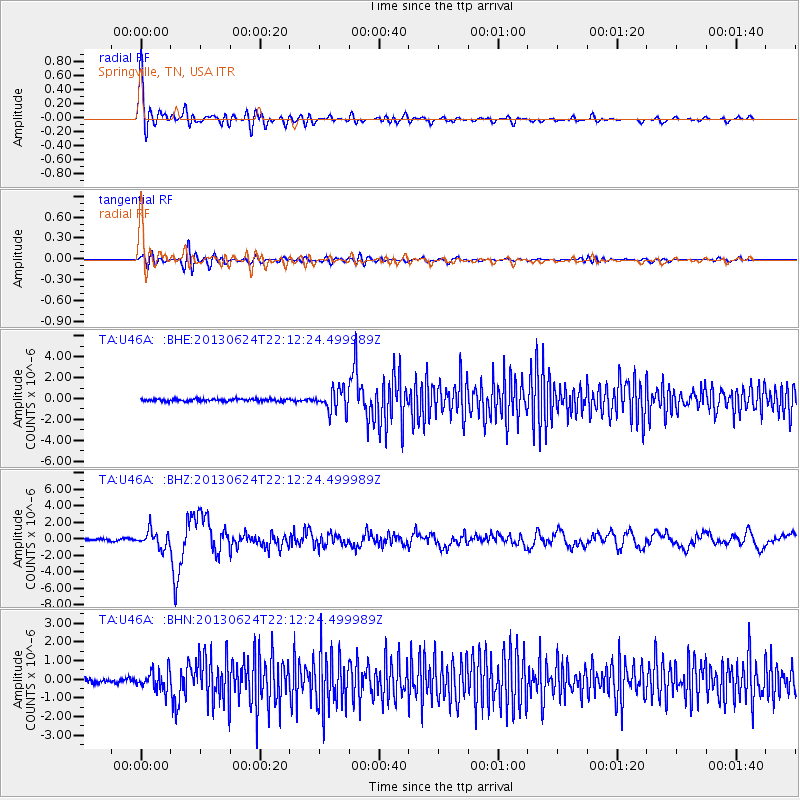
Signal To Noise
| Channel | StoN | STA | LTA |
| TA:U46A: :BHZ:20130624T22:12:24.499989Z | 9.202595 | 1.019992E-6 | 1.1083745E-7 |
| TA:U46A: :BHN:20130624T22:12:24.499989Z | 4.4673667 | 5.0146633E-7 | 1.12250994E-7 |
| TA:U46A: :BHE:20130624T22:12:24.499989Z | 9.15901 | 1.0240153E-6 | 1.11804155E-7 |
| Arrivals |
| Ps | 7.5 SECOND |
| PpPs | 20 SECOND |
| PsPs/PpSs | 28 SECOND |


