You are here: Home > Network List > TA - USArray Transportable Network (new EarthScope stations) Stations List
> Station U53A Fall Branch, TN, USA > Earthquake Result Viewer
U53A Fall Branch, TN, USA - Earthquake Result Viewer
| Earthquake location: |
Northern Mid-Atlantic Ridge |
| Earthquake latitude/longitude: |
10.7/-42.6 |
| Earthquake time(UTC): |
2013/06/24 (175) 22:04:13 GMT |
| Earthquake Depth: |
10 km |
| Earthquake Magnitude: |
6.5 MW, 6.1 MB, 6.3 MS, 6.6 MW |
| Earthquake Catalog/Contributor: |
NEIC PDE/NEIC PDE-W |
|
| Network: |
TA USArray Transportable Network (new EarthScope stations) |
| Station: |
U53A Fall Branch, TN, USA |
| Lat/Lon: |
36.36 N/82.58 W |
| Elevation: |
559 m |
|
| Distance: |
44.2 deg |
| Az: |
311.946 deg |
| Baz: |
115.088 deg |
| Ray Param: |
0.072055854 |
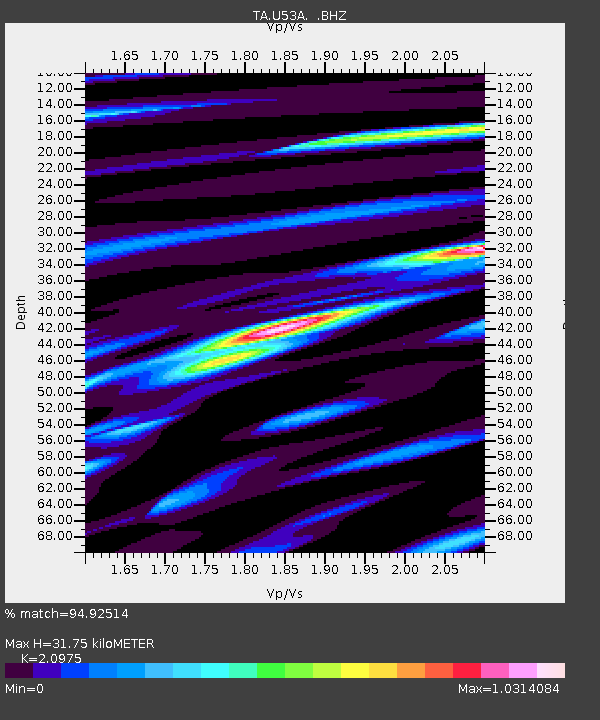
| Estimated Moho Depth: |
31.75 km |
| Estimated Crust Vp/Vs: |
2.10 |
| Assumed Crust Vp: |
6.476 km/s |
| Estimated Crust Vs: |
3.087 km/s |
| Estimated Crust Poisson's Ratio: |
0.35 |
|
| Radial Match: |
94.92514 % |
| Radial Bump: |
329 |
| Transverse Match: |
82.31691 % |
| Transverse Bump: |
400 |
| SOD ConfigId: |
512894 |
| Insert Time: |
2013-09-15 09:50:49.046 +0000 |
| GWidth: |
2.5 |
| Max Bumps: |
400 |
| Tol: |
0.001 |
|
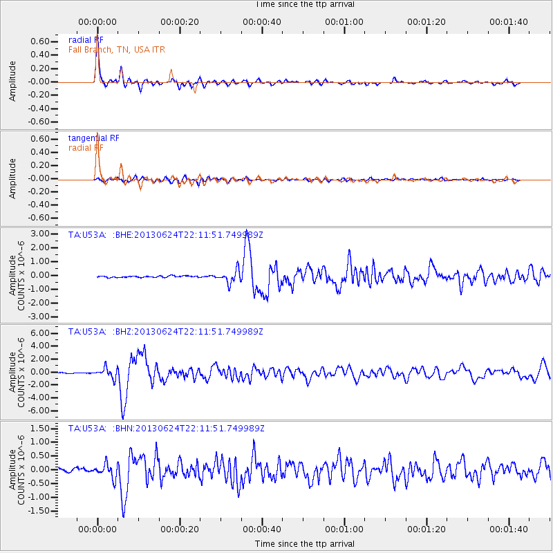
Signal To Noise
| Channel | StoN | STA | LTA |
| TA:U53A: :BHZ:20130624T22:11:51.749989Z | 12.407667 | 7.8869675E-7 | 6.3565274E-8 |
| TA:U53A: :BHN:20130624T22:11:51.749989Z | 5.233704 | 2.605398E-7 | 4.9781146E-8 |
| TA:U53A: :BHE:20130624T22:11:51.749989Z | 8.95974 | 4.7388923E-7 | 5.289096E-8 |
| Arrivals |
| Ps | 5.7 SECOND |
| PpPs | 14 SECOND |
| PsPs/PpSs | 20 SECOND |


