You are here: Home > Network List > TA - USArray Transportable Network (new EarthScope stations) Stations List
> Station U58A Oxford, NC, USA > Earthquake Result Viewer
U58A Oxford, NC, USA - Earthquake Result Viewer
| Earthquake location: |
Northern Mid-Atlantic Ridge |
| Earthquake latitude/longitude: |
10.7/-42.6 |
| Earthquake time(UTC): |
2013/06/24 (175) 22:04:13 GMT |
| Earthquake Depth: |
10 km |
| Earthquake Magnitude: |
6.5 MW, 6.1 MB, 6.3 MS, 6.6 MW |
| Earthquake Catalog/Contributor: |
NEIC PDE/NEIC PDE-W |
|
| Network: |
TA USArray Transportable Network (new EarthScope stations) |
| Station: |
U58A Oxford, NC, USA |
| Lat/Lon: |
36.39 N/78.55 W |
| Elevation: |
169 m |
|
| Distance: |
41.3 deg |
| Az: |
314.165 deg |
| Baz: |
119.096 deg |
| Ray Param: |
0.07385891 |
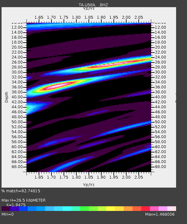
| Estimated Moho Depth: |
26.5 km |
| Estimated Crust Vp/Vs: |
1.95 |
| Assumed Crust Vp: |
6.419 km/s |
| Estimated Crust Vs: |
3.296 km/s |
| Estimated Crust Poisson's Ratio: |
0.32 |
|
| Radial Match: |
92.74815 % |
| Radial Bump: |
400 |
| Transverse Match: |
72.88627 % |
| Transverse Bump: |
400 |
| SOD ConfigId: |
512894 |
| Insert Time: |
2013-09-15 09:51:08.272 +0000 |
| GWidth: |
2.5 |
| Max Bumps: |
400 |
| Tol: |
0.001 |
|
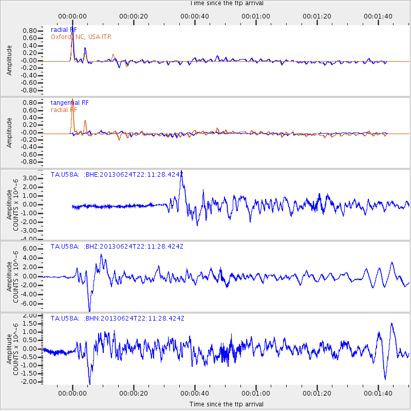
Signal To Noise
| Channel | StoN | STA | LTA |
| TA:U58A: :BHZ:20130624T22:11:28.424Z | 11.511291 | 8.7774816E-7 | 7.625106E-8 |
| TA:U58A: :BHN:20130624T22:11:28.424Z | 2.3308895 | 3.275886E-7 | 1.4054231E-7 |
| TA:U58A: :BHE:20130624T22:11:28.424Z | 5.8766356 | 4.9586845E-7 | 8.437965E-8 |
| Arrivals |
| Ps | 4.2 SECOND |
| PpPs | 11 SECOND |
| PsPs/PpSs | 16 SECOND |


