You are here: Home > Network List > TA - USArray Transportable Network (new EarthScope stations) Stations List
> Station V48A Smith Brothers Farm, Spring Hill, TN, USA > Earthquake Result Viewer
V48A Smith Brothers Farm, Spring Hill, TN, USA - Earthquake Result Viewer
| Earthquake location: |
Northern Mid-Atlantic Ridge |
| Earthquake latitude/longitude: |
10.7/-42.6 |
| Earthquake time(UTC): |
2013/06/24 (175) 22:04:13 GMT |
| Earthquake Depth: |
10 km |
| Earthquake Magnitude: |
6.5 MW, 6.1 MB, 6.3 MS, 6.6 MW |
| Earthquake Catalog/Contributor: |
NEIC PDE/NEIC PDE-W |
|
| Network: |
TA USArray Transportable Network (new EarthScope stations) |
| Station: |
V48A Smith Brothers Farm, Spring Hill, TN, USA |
| Lat/Lon: |
35.74 N/86.82 W |
| Elevation: |
278 m |
|
| Distance: |
47.1 deg |
| Az: |
309.273 deg |
| Baz: |
110.731 deg |
| Ray Param: |
0.07018927 |
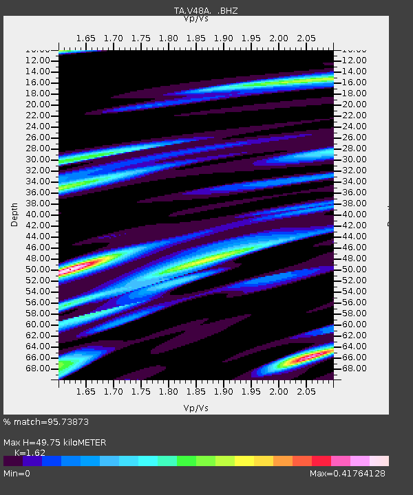
| Estimated Moho Depth: |
49.75 km |
| Estimated Crust Vp/Vs: |
1.62 |
| Assumed Crust Vp: |
6.476 km/s |
| Estimated Crust Vs: |
3.997 km/s |
| Estimated Crust Poisson's Ratio: |
0.19 |
|
| Radial Match: |
95.73873 % |
| Radial Bump: |
351 |
| Transverse Match: |
82.3674 % |
| Transverse Bump: |
400 |
| SOD ConfigId: |
512894 |
| Insert Time: |
2013-09-15 09:51:23.862 +0000 |
| GWidth: |
2.5 |
| Max Bumps: |
400 |
| Tol: |
0.001 |
|

Signal To Noise
| Channel | StoN | STA | LTA |
| TA:V48A: :BHZ:20130624T22:12:14.874989Z | 19.050903 | 1.1670351E-6 | 6.125878E-8 |
| TA:V48A: :BHN:20130624T22:12:14.874989Z | 4.9295354 | 2.239265E-7 | 4.542548E-8 |
| TA:V48A: :BHE:20130624T22:12:14.874989Z | 11.6042595 | 5.554045E-7 | 4.7862123E-8 |
| Arrivals |
| Ps | 5.1 SECOND |
| PpPs | 19 SECOND |
| PsPs/PpSs | 24 SECOND |


