You are here: Home > Network List > TA - USArray Transportable Network (new EarthScope stations) Stations List
> Station V54A Nebo, NC, USA > Earthquake Result Viewer
V54A Nebo, NC, USA - Earthquake Result Viewer
| Earthquake location: |
Northern Mid-Atlantic Ridge |
| Earthquake latitude/longitude: |
10.7/-42.6 |
| Earthquake time(UTC): |
2013/06/24 (175) 22:04:13 GMT |
| Earthquake Depth: |
10 km |
| Earthquake Magnitude: |
6.5 MW, 6.1 MB, 6.3 MS, 6.6 MW |
| Earthquake Catalog/Contributor: |
NEIC PDE/NEIC PDE-W |
|
| Network: |
TA USArray Transportable Network (new EarthScope stations) |
| Station: |
V54A Nebo, NC, USA |
| Lat/Lon: |
35.78 N/81.95 W |
| Elevation: |
448 m |
|
| Distance: |
43.5 deg |
| Az: |
311.492 deg |
| Baz: |
115.129 deg |
| Ray Param: |
0.072511554 |
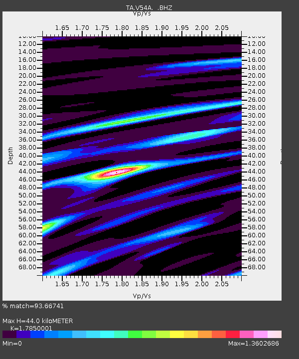
| Estimated Moho Depth: |
44.0 km |
| Estimated Crust Vp/Vs: |
1.79 |
| Assumed Crust Vp: |
6.419 km/s |
| Estimated Crust Vs: |
3.596 km/s |
| Estimated Crust Poisson's Ratio: |
0.27 |
|
| Radial Match: |
93.66741 % |
| Radial Bump: |
395 |
| Transverse Match: |
83.61475 % |
| Transverse Bump: |
400 |
| SOD ConfigId: |
512894 |
| Insert Time: |
2013-09-15 09:51:41.057 +0000 |
| GWidth: |
2.5 |
| Max Bumps: |
400 |
| Tol: |
0.001 |
|

Signal To Noise
| Channel | StoN | STA | LTA |
| TA:V54A: :BHZ:20130624T22:11:46.075001Z | 9.991989 | 7.782872E-7 | 7.7891116E-8 |
| TA:V54A: :BHN:20130624T22:11:46.075001Z | 5.359117 | 2.6444908E-7 | 4.9345644E-8 |
| TA:V54A: :BHE:20130624T22:11:46.075001Z | 8.560232 | 5.018484E-7 | 5.8625556E-8 |
| Arrivals |
| Ps | 5.7 SECOND |
| PpPs | 18 SECOND |
| PsPs/PpSs | 24 SECOND |


