You are here: Home > Network List > TA - USArray Transportable Network (new EarthScope stations) Stations List
> Station W39A Magazine, AR, USA > Earthquake Result Viewer
W39A Magazine, AR, USA - Earthquake Result Viewer
| Earthquake location: |
Northern Mid-Atlantic Ridge |
| Earthquake latitude/longitude: |
10.7/-42.6 |
| Earthquake time(UTC): |
2013/06/24 (175) 22:04:13 GMT |
| Earthquake Depth: |
10 km |
| Earthquake Magnitude: |
6.5 MW, 6.1 MB, 6.3 MS, 6.6 MW |
| Earthquake Catalog/Contributor: |
NEIC PDE/NEIC PDE-W |
|
| Network: |
TA USArray Transportable Network (new EarthScope stations) |
| Station: |
W39A Magazine, AR, USA |
| Lat/Lon: |
35.20 N/93.78 W |
| Elevation: |
162 m |
|
| Distance: |
52.4 deg |
| Az: |
306.326 deg |
| Baz: |
104.8 deg |
| Ray Param: |
0.06679305 |
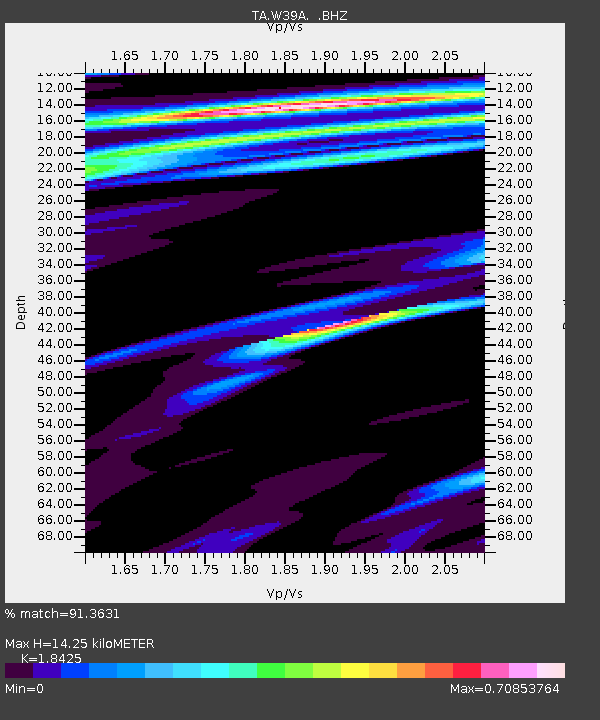
| Estimated Moho Depth: |
14.25 km |
| Estimated Crust Vp/Vs: |
1.84 |
| Assumed Crust Vp: |
6.498 km/s |
| Estimated Crust Vs: |
3.526 km/s |
| Estimated Crust Poisson's Ratio: |
0.29 |
|
| Radial Match: |
91.3631 % |
| Radial Bump: |
400 |
| Transverse Match: |
87.00416 % |
| Transverse Bump: |
400 |
| SOD ConfigId: |
512894 |
| Insert Time: |
2013-09-15 09:52:04.874 +0000 |
| GWidth: |
2.5 |
| Max Bumps: |
400 |
| Tol: |
0.001 |
|

Signal To Noise
| Channel | StoN | STA | LTA |
| TA:W39A: :BHZ:20130624T22:12:54.75002Z | 19.826435 | 1.7128939E-6 | 8.639445E-8 |
| TA:W39A: :BHN:20130624T22:12:54.75002Z | 3.9231534 | 2.8664908E-7 | 7.306599E-8 |
| TA:W39A: :BHE:20130624T22:12:54.75002Z | 2.8625371 | 5.995711E-7 | 2.0945443E-7 |
| Arrivals |
| Ps | 2.0 SECOND |
| PpPs | 5.9 SECOND |
| PsPs/PpSs | 7.9 SECOND |


