You are here: Home > Network List > TA - USArray Transportable Network (new EarthScope stations) Stations List
> Station W46A Michie, TN, USA > Earthquake Result Viewer
W46A Michie, TN, USA - Earthquake Result Viewer
| Earthquake location: |
Northern Mid-Atlantic Ridge |
| Earthquake latitude/longitude: |
10.7/-42.6 |
| Earthquake time(UTC): |
2013/06/24 (175) 22:04:13 GMT |
| Earthquake Depth: |
10 km |
| Earthquake Magnitude: |
6.5 MW, 6.1 MB, 6.3 MS, 6.6 MW |
| Earthquake Catalog/Contributor: |
NEIC PDE/NEIC PDE-W |
|
| Network: |
TA USArray Transportable Network (new EarthScope stations) |
| Station: |
W46A Michie, TN, USA |
| Lat/Lon: |
35.13 N/88.38 W |
| Elevation: |
145 m |
|
| Distance: |
48.1 deg |
| Az: |
307.918 deg |
| Baz: |
108.92 deg |
| Ray Param: |
0.0695559 |
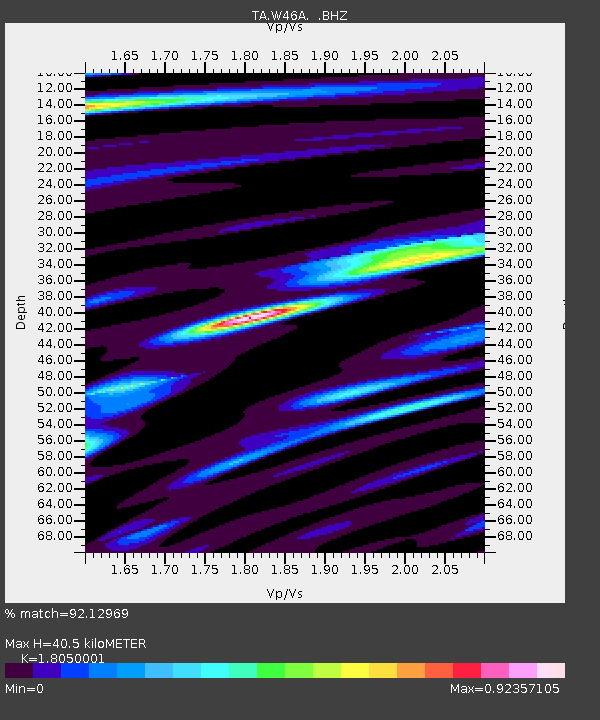
| Estimated Moho Depth: |
40.5 km |
| Estimated Crust Vp/Vs: |
1.81 |
| Assumed Crust Vp: |
6.38 km/s |
| Estimated Crust Vs: |
3.535 km/s |
| Estimated Crust Poisson's Ratio: |
0.28 |
|
| Radial Match: |
92.12969 % |
| Radial Bump: |
322 |
| Transverse Match: |
79.92218 % |
| Transverse Bump: |
400 |
| SOD ConfigId: |
512894 |
| Insert Time: |
2013-09-15 09:52:10.350 +0000 |
| GWidth: |
2.5 |
| Max Bumps: |
400 |
| Tol: |
0.001 |
|
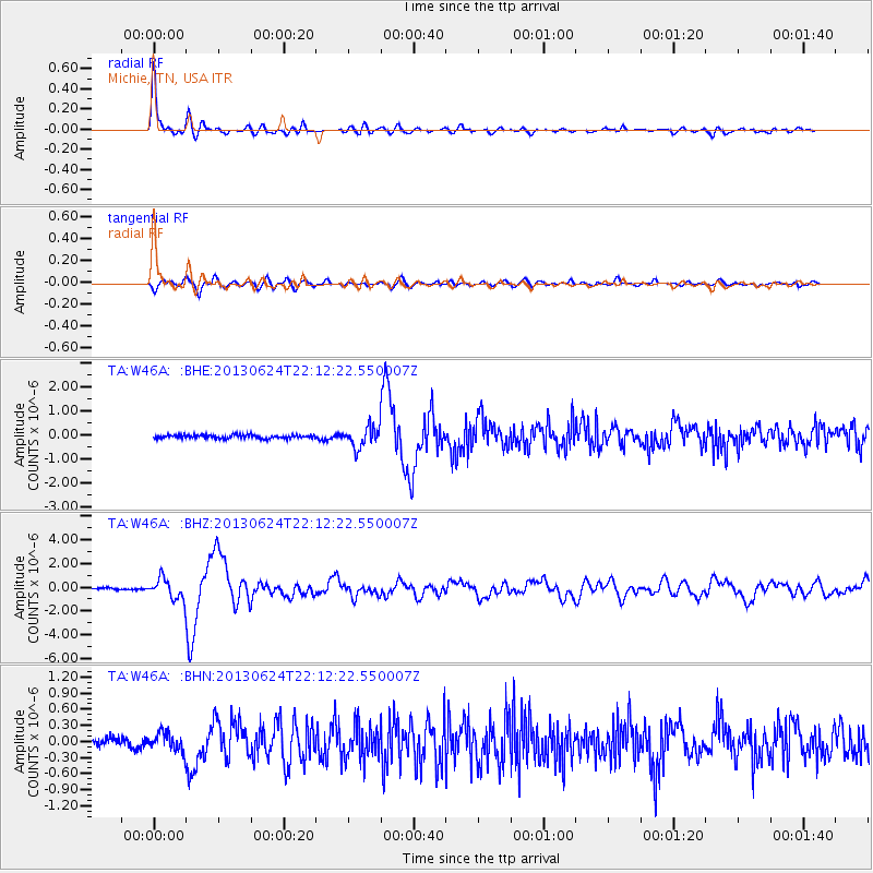
Signal To Noise
| Channel | StoN | STA | LTA |
| TA:W46A: :BHZ:20130624T22:12:22.550007Z | 10.828931 | 8.628689E-7 | 7.968181E-8 |
| TA:W46A: :BHN:20130624T22:12:22.550007Z | 2.5317125 | 1.7290292E-7 | 6.8294845E-8 |
| TA:W46A: :BHE:20130624T22:12:22.550007Z | 6.060775 | 4.1533855E-7 | 6.8528955E-8 |
| Arrivals |
| Ps | 5.4 SECOND |
| PpPs | 17 SECOND |
| PsPs/PpSs | 22 SECOND |


