You are here: Home > Network List > UW - Pacific Northwest Regional Seismic Network Stations List
> Station LON Longmire (broad-band and DWWSSN) > Earthquake Result Viewer
LON Longmire (broad-band and DWWSSN) - Earthquake Result Viewer

| Earthquake location: |
Fiji Islands Region |
| Earthquake latitude/longitude: |
-17.8/-178.5 |
| Earthquake time(UTC): |
1994/03/09 (068) 23:28:07 GMT |
| Earthquake Depth: |
564 km |
| Earthquake Magnitude: |
6.6 MB, 7.6 UNKNOWN, 7.6 MW |
| Earthquake Catalog/Contributor: |
WHDF/NEIC |
|
| Network: |
UW Pacific Northwest Regional Seismic Network |
| Station: |
LON Longmire (broad-band and DWWSSN) |
| Lat/Lon: |
46.75 N/121.81 W |
| Elevation: |
850 m |
|
| Distance: |
82.0 deg |
| Az: |
35.475 deg |
| Baz: |
233.538 deg |
| Ray Param: |
0.045535468 |
| Estimated Moho Depth: |
47.0 km |
| Estimated Crust Vp/Vs: |
1.68 |
| Assumed Crust Vp: |
6.597 km/s |
| Estimated Crust Vs: |
3.939 km/s |
| Estimated Crust Poisson's Ratio: |
0.22 |
|
| Radial Match: |
89.642426 % |
| Radial Bump: |
378 |
| Transverse Match: |
80.78122 % |
| Transverse Bump: |
400 |
| SOD ConfigId: |
4480 |
| Insert Time: |
2010-02-27 04:44:05.610 +0000 |
| GWidth: |
2.5 |
| Max Bumps: |
400 |
| Tol: |
0.001 |
|
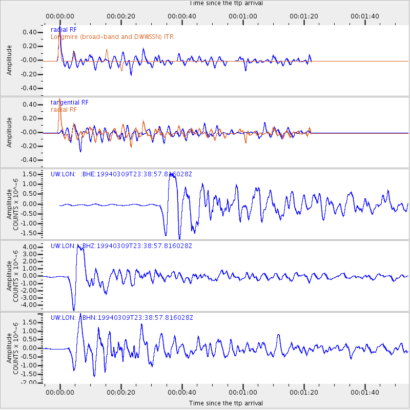
Signal To Noise
| Channel | StoN | STA | LTA |
| UW:LON: :BHZ:19940309T23:38:57.816028Z | 51.34177 | 1.7170878E-6 | 3.3444266E-8 |
| UW:LON: :BHN:19940309T23:38:57.816028Z | 23.250908 | 4.0962138E-7 | 1.7617436E-8 |
| UW:LON: :BHE:19940309T23:38:57.816028Z | 20.287287 | 5.3096716E-7 | 2.6172406E-8 |
| Arrivals |
| Ps | 4.9 SECOND |
| PpPs | 19 SECOND |
| PsPs/PpSs | 23 SECOND |


