You are here: Home > Network List > TA - USArray Transportable Network (new EarthScope stations) Stations List
> Station Y50A Piedmont, AL, USA > Earthquake Result Viewer
Y50A Piedmont, AL, USA - Earthquake Result Viewer
| Earthquake location: |
Northern Mid-Atlantic Ridge |
| Earthquake latitude/longitude: |
10.7/-42.6 |
| Earthquake time(UTC): |
2013/06/24 (175) 22:04:13 GMT |
| Earthquake Depth: |
10 km |
| Earthquake Magnitude: |
6.5 MW, 6.1 MB, 6.3 MS, 6.6 MW |
| Earthquake Catalog/Contributor: |
NEIC PDE/NEIC PDE-W |
|
| Network: |
TA USArray Transportable Network (new EarthScope stations) |
| Station: |
Y50A Piedmont, AL, USA |
| Lat/Lon: |
33.89 N/85.73 W |
| Elevation: |
248 m |
|
| Distance: |
45.7 deg |
| Az: |
307.315 deg |
| Baz: |
109.998 deg |
| Ray Param: |
0.07113298 |
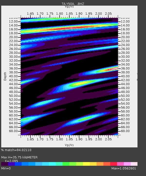
| Estimated Moho Depth: |
35.75 km |
| Estimated Crust Vp/Vs: |
2.10 |
| Assumed Crust Vp: |
6.719 km/s |
| Estimated Crust Vs: |
3.207 km/s |
| Estimated Crust Poisson's Ratio: |
0.35 |
|
| Radial Match: |
94.82118 % |
| Radial Bump: |
400 |
| Transverse Match: |
88.33792 % |
| Transverse Bump: |
400 |
| SOD ConfigId: |
512894 |
| Insert Time: |
2013-09-15 09:53:58.205 +0000 |
| GWidth: |
2.5 |
| Max Bumps: |
400 |
| Tol: |
0.001 |
|
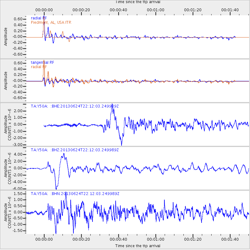
Signal To Noise
| Channel | StoN | STA | LTA |
| TA:Y50A: :BHZ:20130624T22:12:03.249989Z | 9.584011 | 8.2074956E-7 | 8.563738E-8 |
| TA:Y50A: :BHN:20130624T22:12:03.249989Z | 4.2364554 | 3.0768828E-7 | 7.2628715E-8 |
| TA:Y50A: :BHE:20130624T22:12:03.249989Z | 4.4058456 | 4.1904977E-7 | 9.511222E-8 |
| Arrivals |
| Ps | 6.2 SECOND |
| PpPs | 16 SECOND |
| PsPs/PpSs | 22 SECOND |


