You are here: Home > Network List > US - United States National Seismic Network Stations List
> Station DGMT Dagmar, Montana, USA > Earthquake Result Viewer
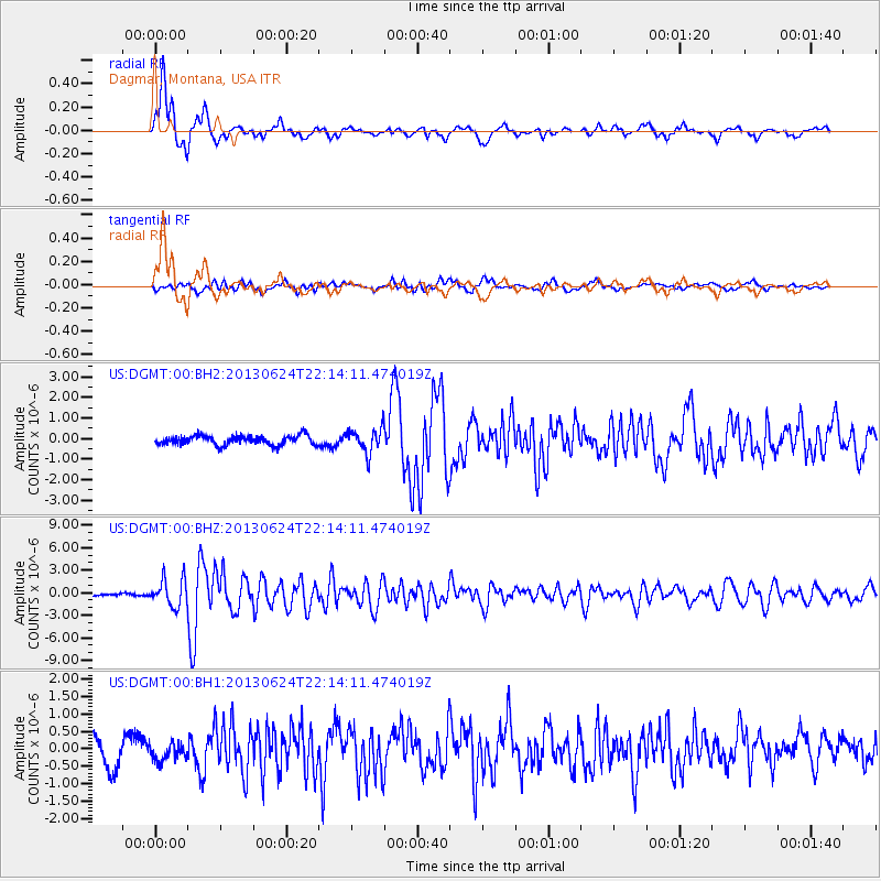
DGMT Dagmar, Montana, USA - Earthquake Result Viewer
*The percent match for this event was below the threshold and hence no stack was calculated.
| Earthquake location: |
Northern Mid-Atlantic Ridge |
| Earthquake latitude/longitude: |
10.7/-42.6 |
| Earthquake time(UTC): |
2013/06/24 (175) 22:04:13 GMT |
| Earthquake Depth: |
10 km |
| Earthquake Magnitude: |
6.5 MW, 6.1 MB, 6.3 MS, 6.6 MW |
| Earthquake Catalog/Contributor: |
NEIC PDE/NEIC PDE-W |
|
| Network: |
US United States National Seismic Network |
| Station: |
DGMT Dagmar, Montana, USA |
| Lat/Lon: |
48.47 N/104.20 W |
| Elevation: |
0.0 m |
|
| Distance: |
63.3 deg |
| Az: |
319.074 deg |
| Baz: |
104.657 deg |
| Ray Param: |
$rayparam |
*The percent match for this event was below the threshold and hence was not used in the summary stack. |
|
| Radial Match: |
93.01112 % |
| Radial Bump: |
400 |
| Transverse Match: |
71.60617 % |
| Transverse Bump: |
400 |
| SOD ConfigId: |
512894 |
| Insert Time: |
2013-09-15 09:55:57.151 +0000 |
| GWidth: |
2.5 |
| Max Bumps: |
400 |
| Tol: |
0.001 |
|
Signal To Noise
| Channel | StoN | STA | LTA |
| US:DGMT:00:BHZ:20130624T22:14:11.474019Z | 13.3116665 | 1.7970638E-6 | 1.3499915E-7 |
| US:DGMT:00:BH1:20130624T22:14:11.474019Z | 0.61490273 | 2.3801442E-7 | 3.8707654E-7 |
| US:DGMT:00:BH2:20130624T22:14:11.474019Z | 2.614503 | 5.935084E-7 | 2.270062E-7 |
| Arrivals |
| Ps | |
| PpPs | |
| PsPs/PpSs | |


