You are here: Home > Network List > US - United States National Seismic Network Stations List
> Station ECSD EROS Data Center, Sioux Falls, South Dakota, USA > Earthquake Result Viewer
ECSD EROS Data Center, Sioux Falls, South Dakota, USA - Earthquake Result Viewer
| Earthquake location: |
Northern Mid-Atlantic Ridge |
| Earthquake latitude/longitude: |
10.7/-42.6 |
| Earthquake time(UTC): |
2013/06/24 (175) 22:04:13 GMT |
| Earthquake Depth: |
10 km |
| Earthquake Magnitude: |
6.5 MW, 6.1 MB, 6.3 MS, 6.6 MW |
| Earthquake Catalog/Contributor: |
NEIC PDE/NEIC PDE-W |
|
| Network: |
US United States National Seismic Network |
| Station: |
ECSD EROS Data Center, Sioux Falls, South Dakota, USA |
| Lat/Lon: |
43.73 N/96.61 W |
| Elevation: |
478 m |
|
| Distance: |
56.9 deg |
| Az: |
315.576 deg |
| Baz: |
108.366 deg |
| Ray Param: |
0.06381846 |
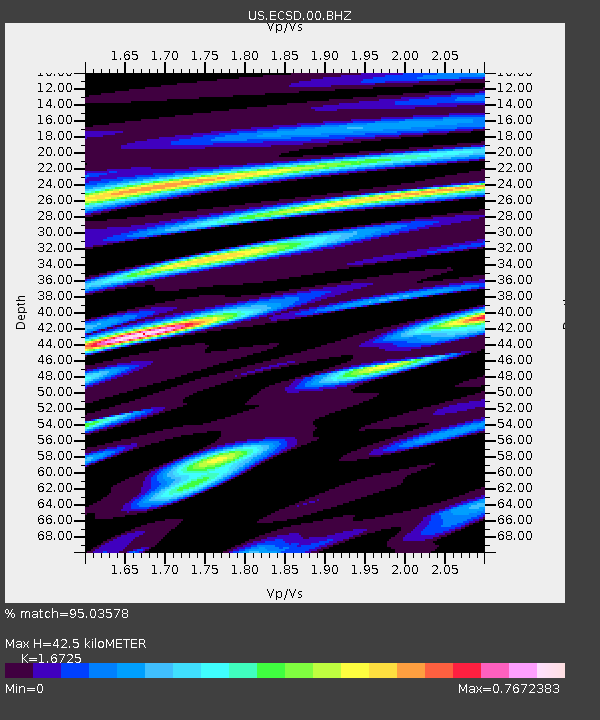
| Estimated Moho Depth: |
42.5 km |
| Estimated Crust Vp/Vs: |
1.67 |
| Assumed Crust Vp: |
6.498 km/s |
| Estimated Crust Vs: |
3.885 km/s |
| Estimated Crust Poisson's Ratio: |
0.22 |
|
| Radial Match: |
95.03578 % |
| Radial Bump: |
400 |
| Transverse Match: |
85.23701 % |
| Transverse Bump: |
400 |
| SOD ConfigId: |
512894 |
| Insert Time: |
2013-09-15 09:56:02.321 +0000 |
| GWidth: |
2.5 |
| Max Bumps: |
400 |
| Tol: |
0.001 |
|

Signal To Noise
| Channel | StoN | STA | LTA |
| US:ECSD:00:BHZ:20130624T22:13:27.649983Z | 29.322636 | 2.1074407E-6 | 7.187078E-8 |
| US:ECSD:00:BH1:20130624T22:13:27.649983Z | 5.999886 | 2.7222973E-7 | 4.5372484E-8 |
| US:ECSD:00:BH2:20130624T22:13:27.649983Z | 32.263676 | 1.226405E-6 | 3.801194E-8 |
| Arrivals |
| Ps | 4.6 SECOND |
| PpPs | 17 SECOND |
| PsPs/PpSs | 21 SECOND |


