You are here: Home > Network List > US - United States National Seismic Network Stations List
> Station HAWA Hanford, Washington, USA > Earthquake Result Viewer
HAWA Hanford, Washington, USA - Earthquake Result Viewer
| Earthquake location: |
Northern Mid-Atlantic Ridge |
| Earthquake latitude/longitude: |
10.7/-42.6 |
| Earthquake time(UTC): |
2013/06/24 (175) 22:04:13 GMT |
| Earthquake Depth: |
10 km |
| Earthquake Magnitude: |
6.5 MW, 6.1 MB, 6.3 MS, 6.6 MW |
| Earthquake Catalog/Contributor: |
NEIC PDE/NEIC PDE-W |
|
| Network: |
US United States National Seismic Network |
| Station: |
HAWA Hanford, Washington, USA |
| Lat/Lon: |
46.39 N/119.53 W |
| Elevation: |
364 m |
|
| Distance: |
73.3 deg |
| Az: |
315.266 deg |
| Baz: |
91.952 deg |
| Ray Param: |
0.053077035 |
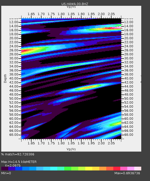
| Estimated Moho Depth: |
14.5 km |
| Estimated Crust Vp/Vs: |
2.10 |
| Assumed Crust Vp: |
6.419 km/s |
| Estimated Crust Vs: |
3.06 km/s |
| Estimated Crust Poisson's Ratio: |
0.35 |
|
| Radial Match: |
92.728386 % |
| Radial Bump: |
400 |
| Transverse Match: |
80.61546 % |
| Transverse Bump: |
400 |
| SOD ConfigId: |
512894 |
| Insert Time: |
2013-09-15 09:56:20.106 +0000 |
| GWidth: |
2.5 |
| Max Bumps: |
400 |
| Tol: |
0.001 |
|

Signal To Noise
| Channel | StoN | STA | LTA |
| US:HAWA:00:BHZ:20130624T22:15:13.899006Z | 7.284705 | 7.658986E-7 | 1.051379E-7 |
| US:HAWA:00:BH1:20130624T22:15:13.899006Z | 1.1402953 | 7.776653E-8 | 6.8198595E-8 |
| US:HAWA:00:BH2:20130624T22:15:13.899006Z | 3.0341501 | 2.4336418E-7 | 8.020836E-8 |
| Arrivals |
| Ps | 2.6 SECOND |
| PpPs | 6.8 SECOND |
| PsPs/PpSs | 9.3 SECOND |


