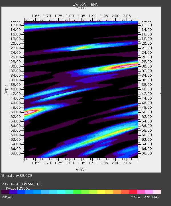
LON Longmire (broad-band and DWWSSN) - Earthquake Result Viewer
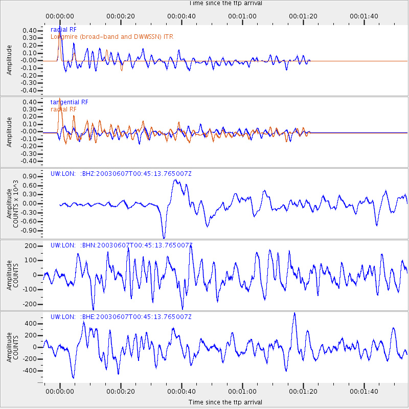
Earthquake location: New Britain Region, P.N.G.
Earthquake latitude/longitude: -5.1/152.5
Earthquake time(UTC): 2003/06/07 (158) 00:32:45 GMT
Earthquake Depth: 33 km
Earthquake Magnitude: 6.0 MB, 6.8 MS, 6.6 MW, 6.5 MW
Earthquake Catalog/Contributor: WHDF/NEIC
Network: UW Pacific Northwest Regional Seismic Network
Station: LON Longmire (broad-band and DWWSSN)
Lat/Lon: 46.75 N/121.81 W
Elevation: 850 m
Distance: 90.7 deg
Az: 43.293 deg
Baz: 263.394 deg
Ray Param: 0.041649345
Estimated Moho Depth: 50.0 km
Estimated Crust Vp/Vs: 1.61
Assumed Crust Vp: 6.597 km/s
Estimated Crust Vs: 4.091 km/s
Estimated Crust Poisson's Ratio: 0.19
Radial Match: 88.928 %
Radial Bump: 400
Transverse Match: 70.59534 %
Transverse Bump: 400
SOD ConfigId: 4714
Insert Time: 2010-02-27 04:44:28.221 +0000
GWidth: 2.5
Max Bumps: 400
Tol: 0.001

Signal To Noise

ChannelStoNSTALTA
UW:LON: :BHN:20030607T00:45:13.765007Z1.407455641.3110129.351555
UW:LON: :BHE:20030607T00:45:13.765007Z4.7147213.3723345.256817
UW:LON: :BHZ:20030607T00:45:13.765007Z9.597946484.262250.454773
Arrivals
Ps4.8 SECOND
PpPs19 SECOND
PsPs/PpSs24 SECOND