You are here: Home > Network List > US - United States National Seismic Network Stations List
> Station JFWS Jewell Farm, Wisconsin, USA > Earthquake Result Viewer
JFWS Jewell Farm, Wisconsin, USA - Earthquake Result Viewer

| Earthquake location: |
Northern Mid-Atlantic Ridge |
| Earthquake latitude/longitude: |
10.7/-42.6 |
| Earthquake time(UTC): |
2013/06/24 (175) 22:04:13 GMT |
| Earthquake Depth: |
10 km |
| Earthquake Magnitude: |
6.5 MW, 6.1 MB, 6.3 MS, 6.6 MW |
| Earthquake Catalog/Contributor: |
NEIC PDE/NEIC PDE-W |
|
| Network: |
US United States National Seismic Network |
| Station: |
JFWS Jewell Farm, Wisconsin, USA |
| Lat/Lon: |
42.91 N/90.25 W |
| Elevation: |
335 m |
|
| Distance: |
52.3 deg |
| Az: |
316.666 deg |
| Baz: |
113.353 deg |
| Ray Param: |
0.06684796 |
| Estimated Moho Depth: |
34.5 km |
| Estimated Crust Vp/Vs: |
1.93 |
| Assumed Crust Vp: |
6.53 km/s |
| Estimated Crust Vs: |
3.375 km/s |
| Estimated Crust Poisson's Ratio: |
0.32 |
|
| Radial Match: |
95.24654 % |
| Radial Bump: |
400 |
| Transverse Match: |
86.083435 % |
| Transverse Bump: |
400 |
| SOD ConfigId: |
512894 |
| Insert Time: |
2013-09-15 09:56:33.165 +0000 |
| GWidth: |
2.5 |
| Max Bumps: |
400 |
| Tol: |
0.001 |
|
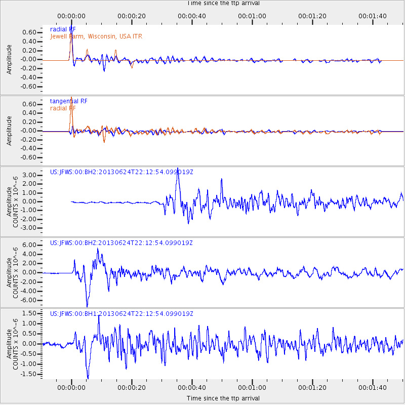
Signal To Noise
| Channel | StoN | STA | LTA |
| US:JFWS:00:BHZ:20130624T22:12:54.099019Z | 19.391922 | 1.2251624E-6 | 6.317901E-8 |
| US:JFWS:00:BH1:20130624T22:12:54.099019Z | 5.380419 | 2.9211503E-7 | 5.4292247E-8 |
| US:JFWS:00:BH2:20130624T22:12:54.099019Z | 15.323793 | 6.9426784E-7 | 4.530653E-8 |
| Arrivals |
| Ps | 5.2 SECOND |
| PpPs | 15 SECOND |
| PsPs/PpSs | 20 SECOND |


