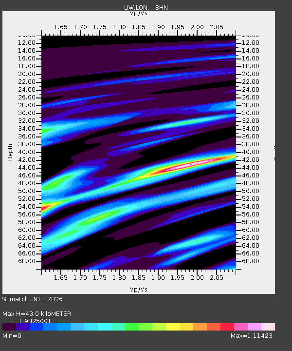
LON Longmire (broad-band and DWWSSN) - Earthquake Result Viewer
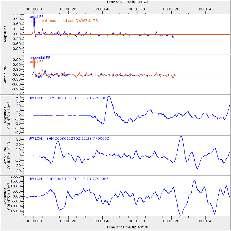
Earthquake location: Near Coast Of Jalisco, Mexico
Earthquake latitude/longitude: 18.8/-104.1
Earthquake time(UTC): 2003/01/22 (022) 02:06:34 GMT
Earthquake Depth: 24 km
Earthquake Magnitude: 6.5 MB, 7.6 MS, 7.6 MW, 7.4 MW
Earthquake Catalog/Contributor: WHDF/NEIC
Network: UW Pacific Northwest Regional Seismic Network
Station: LON Longmire (broad-band and DWWSSN)
Lat/Lon: 46.75 N/121.81 W
Elevation: 850 m
Distance: 31.5 deg
Az: 336.389 deg
Baz: 146.504 deg
Ray Param: 0.07903202
Estimated Moho Depth: 43.0 km
Estimated Crust Vp/Vs: 1.98
Assumed Crust Vp: 6.597 km/s
Estimated Crust Vs: 3.328 km/s
Estimated Crust Poisson's Ratio: 0.33
Radial Match: 91.17826 %
Radial Bump: 400
Transverse Match: 86.77661 %
Transverse Bump: 400
SOD ConfigId: 4714
Insert Time: 2010-02-27 04:44:29.898 +0000
GWidth: 2.5
Max Bumps: 400
Tol: 0.001

Signal To Noise

ChannelStoNSTALTA
UW:LON: :BHN:20030122T02:12:23.779006Z4.9302981266.8987256.96188
UW:LON: :BHE:20030122T02:12:23.779006Z2.2080405465.22974210.69801
UW:LON: :BHZ:20030122T02:12:23.779006Z3.95919682013.678508.6077
Arrivals
Ps6.9 SECOND
PpPs18 SECOND
PsPs/PpSs25 SECOND