You are here: Home > Network List > UU - University of Utah Regional Network Stations List
> Station BRPU Butcher Ranch, Price, UT, USA old TA-P17A > Earthquake Result Viewer
BRPU Butcher Ranch, Price, UT, USA old TA-P17A - Earthquake Result Viewer
| Earthquake location: |
Northern Mid-Atlantic Ridge |
| Earthquake latitude/longitude: |
10.7/-42.6 |
| Earthquake time(UTC): |
2013/06/24 (175) 22:04:13 GMT |
| Earthquake Depth: |
10 km |
| Earthquake Magnitude: |
6.5 MW, 6.1 MB, 6.3 MS, 6.6 MW |
| Earthquake Catalog/Contributor: |
NEIC PDE/NEIC PDE-W |
|
| Network: |
UU University of Utah Regional Network |
| Station: |
BRPU Butcher Ranch, Price, UT, USA old TA-P17A |
| Lat/Lon: |
39.47 N/110.74 W |
| Elevation: |
1687 m |
|
| Distance: |
66.4 deg |
| Az: |
308.388 deg |
| Baz: |
95.563 deg |
| Ray Param: |
0.057626348 |
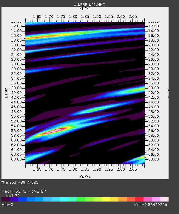
| Estimated Moho Depth: |
55.75 km |
| Estimated Crust Vp/Vs: |
1.72 |
| Assumed Crust Vp: |
6.207 km/s |
| Estimated Crust Vs: |
3.609 km/s |
| Estimated Crust Poisson's Ratio: |
0.24 |
|
| Radial Match: |
89.77685 % |
| Radial Bump: |
389 |
| Transverse Match: |
70.6041 % |
| Transverse Bump: |
400 |
| SOD ConfigId: |
512894 |
| Insert Time: |
2013-09-15 09:57:50.236 +0000 |
| GWidth: |
2.5 |
| Max Bumps: |
400 |
| Tol: |
0.001 |
|

Signal To Noise
| Channel | StoN | STA | LTA |
| UU:BRPU:01:HHZ:20130624T22:14:31.527974Z | 10.825828 | 2.3270097E-8 | 2.1494981E-9 |
| UU:BRPU:01:HHN:20130624T22:14:31.527974Z | 0.7051802 | 3.578539E-9 | 5.0746443E-9 |
| UU:BRPU:01:HHE:20130624T22:14:31.527974Z | 5.736939 | 1.1688133E-8 | 2.0373465E-9 |
| Arrivals |
| Ps | 6.7 SECOND |
| PpPs | 23 SECOND |
| PsPs/PpSs | 30 SECOND |


