LON Longmire (broad-band and DWWSSN) - Earthquake Result Viewer
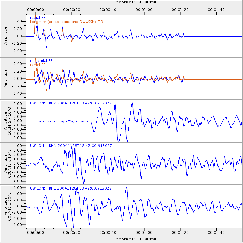
Earthquake location: Hokkaido, Japan Region
Earthquake latitude/longitude: 43.0/145.1
Earthquake time(UTC): 2004/11/28 (333) 18:32:14 GMT
Earthquake Depth: 39 km
Earthquake Magnitude: 6.4 MB, 6.7 MS, 7.0 MW, 7.0 MW
Earthquake Catalog/Contributor: WHDF/NEIC
Network: UW Pacific Northwest Regional Seismic Network
Station: LON Longmire (broad-band and DWWSSN)
Lat/Lon: 46.75 N/121.81 W
Elevation: 850 m
Distance: 62.2 deg
Az: 50.918 deg
Baz: 304.095 deg
Ray Param: 0.060311478
Estimated Moho Depth: 13.25 km
Estimated Crust Vp/Vs: 1.61
Assumed Crust Vp: 6.597 km/s
Estimated Crust Vs: 4.111 km/s
Estimated Crust Poisson's Ratio: 0.18
Radial Match: 94.63772 %
Radial Bump: 389
Transverse Match: 89.73283 %
Transverse Bump: 400
SOD ConfigId: 2459
Insert Time: 2010-02-27 04:44:50.045 +0000
GWidth: 2.5
Max Bumps: 400
Tol: 0.001

Signal To Noise

ChannelStoNSTALTA
UW:LON: :BHN:20041128T18:42:00.91302Z4.8803167736.15314150.84126
UW:LON: :BHE:20041128T18:42:00.91302Z7.5582891319.9039174.62999
UW:LON: :BHZ:20041128T18:42:00.91302Z11.3875582683.44235.64665
Arrivals
Ps1.3 SECOND
PpPs5.0 SECOND
PsPs/PpSs6.2 SECOND