You are here: Home > Network List > WY - Yellowstone Wyoming Seismic Network Stations List
> Station YMR Madison River, YNP, WY, USA > Earthquake Result Viewer
YMR Madison River, YNP, WY, USA - Earthquake Result Viewer
| Earthquake location: |
Northern Mid-Atlantic Ridge |
| Earthquake latitude/longitude: |
10.7/-42.6 |
| Earthquake time(UTC): |
2013/06/24 (175) 22:04:13 GMT |
| Earthquake Depth: |
10 km |
| Earthquake Magnitude: |
6.5 MW, 6.1 MB, 6.3 MS, 6.6 MW |
| Earthquake Catalog/Contributor: |
NEIC PDE/NEIC PDE-W |
|
| Network: |
WY Yellowstone Wyoming Seismic Network |
| Station: |
YMR Madison River, YNP, WY, USA |
| Lat/Lon: |
44.67 N/110.96 W |
| Elevation: |
2149 m |
|
| Distance: |
67.2 deg |
| Az: |
313.979 deg |
| Baz: |
97.617 deg |
| Ray Param: |
0.05712085 |
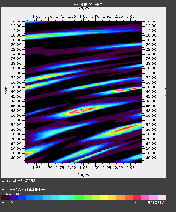
| Estimated Moho Depth: |
47.75 km |
| Estimated Crust Vp/Vs: |
1.84 |
| Assumed Crust Vp: |
6.35 km/s |
| Estimated Crust Vs: |
3.451 km/s |
| Estimated Crust Poisson's Ratio: |
0.29 |
|
| Radial Match: |
84.52934 % |
| Radial Bump: |
400 |
| Transverse Match: |
74.941925 % |
| Transverse Bump: |
400 |
| SOD ConfigId: |
512894 |
| Insert Time: |
2013-09-15 10:01:39.310 +0000 |
| GWidth: |
2.5 |
| Max Bumps: |
400 |
| Tol: |
0.001 |
|

Signal To Noise
| Channel | StoN | STA | LTA |
| WY:YMR:01:HHZ:20130624T22:14:36.38802Z | 9.137829 | 2.6098256E-8 | 2.8560674E-9 |
| WY:YMR:01:HHN:20130624T22:14:36.38802Z | 1.8016914 | 8.237867E-9 | 4.5722963E-9 |
| WY:YMR:01:HHE:20130624T22:14:36.38802Z | 4.254303 | 1.3671286E-8 | 3.2135197E-9 |
| Arrivals |
| Ps | 6.6 SECOND |
| PpPs | 21 SECOND |
| PsPs/PpSs | 27 SECOND |


