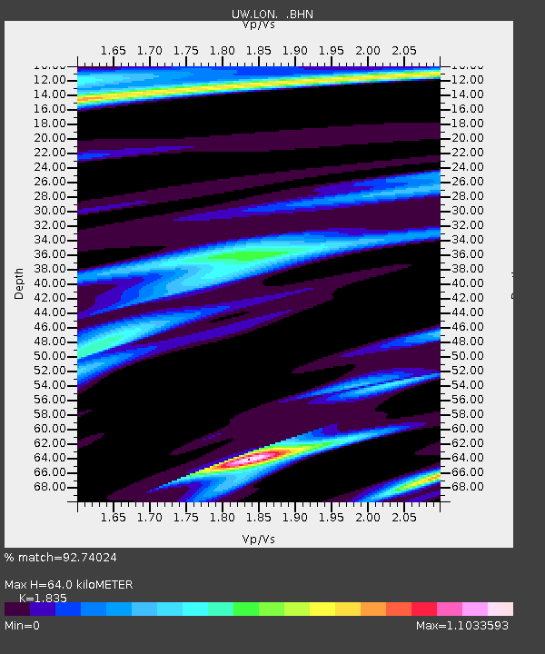
LON Longmire (broad-band and DWWSSN) - Earthquake Result Viewer
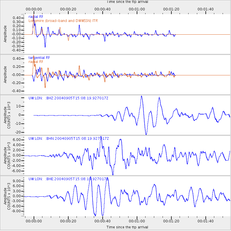
Earthquake location: Near S. Coast Of Honshu, Japan
Earthquake latitude/longitude: 33.2/137.1
Earthquake time(UTC): 2004/09/05 (249) 14:57:18 GMT
Earthquake Depth: 10 km
Earthquake Magnitude: 6.2 MB, 7.1 MS, 7.4 MW, 7.4 MW
Earthquake Catalog/Contributor: WHDF/NEIC
Network: UW Pacific Northwest Regional Seismic Network
Station: LON Longmire (broad-band and DWWSSN)
Lat/Lon: 46.75 N/121.81 W
Elevation: 850 m
Distance: 73.5 deg
Az: 44.729 deg
Baz: 300.876 deg
Ray Param: 0.05297514
Estimated Moho Depth: 64.0 km
Estimated Crust Vp/Vs: 1.84
Assumed Crust Vp: 6.597 km/s
Estimated Crust Vs: 3.595 km/s
Estimated Crust Poisson's Ratio: 0.29
Radial Match: 92.74024 %
Radial Bump: 311
Transverse Match: 87.783714 %
Transverse Bump: 400
SOD ConfigId: 2459
Insert Time: 2010-02-27 04:45:18.753 +0000
GWidth: 2.5
Max Bumps: 400
Tol: 0.001

Signal To Noise

ChannelStoNSTALTA
UW:LON: :BHN:20040905T15:08:19.927017Z1.635274475.9016446.41523
UW:LON: :BHE:20040905T15:08:19.927017Z1.2008122106.3420288.55841
UW:LON: :BHZ:20040905T15:08:19.927017Z3.172828242.0234576.280045
Arrivals
Ps8.4 SECOND
PpPs27 SECOND
PsPs/PpSs35 SECOND