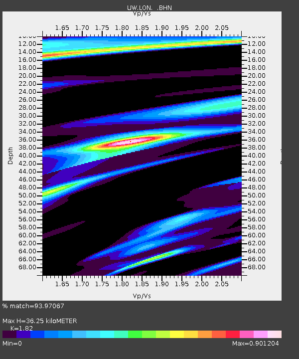
LON Longmire (broad-band and DWWSSN) - Earthquake Result Viewer
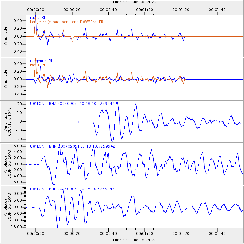
Earthquake location: Near S. Coast Of Western Honshu
Earthquake latitude/longitude: 33.1/136.6
Earthquake time(UTC): 2004/09/05 (249) 10:07:07 GMT
Earthquake Depth: 14 km
Earthquake Magnitude: 6.7 MB, 7.0 MS, 7.2 MW, 7.0 MW
Earthquake Catalog/Contributor: WHDF/NEIC
Network: UW Pacific Northwest Regional Seismic Network
Station: LON Longmire (broad-band and DWWSSN)
Lat/Lon: 46.75 N/121.81 W
Elevation: 850 m
Distance: 73.8 deg
Az: 44.539 deg
Baz: 301.075 deg
Ray Param: 0.05273493
Estimated Moho Depth: 36.25 km
Estimated Crust Vp/Vs: 1.82
Assumed Crust Vp: 6.597 km/s
Estimated Crust Vs: 3.625 km/s
Estimated Crust Poisson's Ratio: 0.28
Radial Match: 93.97067 %
Radial Bump: 238
Transverse Match: 88.95378 %
Transverse Bump: 400
SOD ConfigId: 2459
Insert Time: 2010-02-27 04:45:23.248 +0000
GWidth: 2.5
Max Bumps: 400
Tol: 0.001

Signal To Noise

ChannelStoNSTALTA
UW:LON: :BHN:20040905T10:18:10.525994Z21.818141325.213660.739075
UW:LON: :BHE:20040905T10:18:10.525994Z62.996873241.98151.46257
UW:LON: :BHZ:20040905T10:18:10.525994Z117.5790946708.894557.058567
Arrivals
Ps4.7 SECOND
PpPs15 SECOND
PsPs/PpSs20 SECOND