You are here: Home > Network List > UW - Pacific Northwest Regional Seismic Network Stations List
> Station LON Longmire (broad-band and DWWSSN) > Earthquake Result Viewer
LON Longmire (broad-band and DWWSSN) - Earthquake Result Viewer
| Earthquake location: |
Kuril Islands |
| Earthquake latitude/longitude: |
47.2/151.3 |
| Earthquake time(UTC): |
2004/07/08 (190) 10:30:49 GMT |
| Earthquake Depth: |
128 km |
| Earthquake Magnitude: |
5.9 MB, 6.4 MW, 6.3 MW |
| Earthquake Catalog/Contributor: |
WHDF/NEIC |
|
| Network: |
UW Pacific Northwest Regional Seismic Network |
| Station: |
LON Longmire (broad-band and DWWSSN) |
| Lat/Lon: |
46.75 N/121.81 W |
| Elevation: |
850 m |
|
| Distance: |
56.2 deg |
| Az: |
55.732 deg |
| Baz: |
304.959 deg |
| Ray Param: |
0.063903585 |
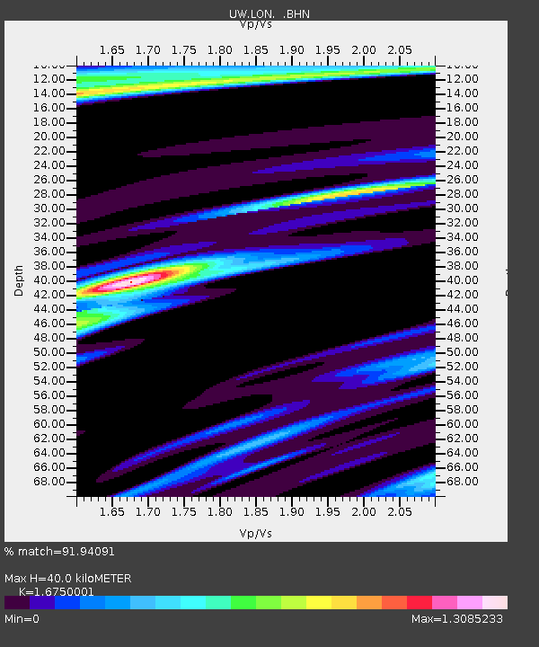
| Estimated Moho Depth: |
40.0 km |
| Estimated Crust Vp/Vs: |
1.68 |
| Assumed Crust Vp: |
6.597 km/s |
| Estimated Crust Vs: |
3.939 km/s |
| Estimated Crust Poisson's Ratio: |
0.22 |
|
| Radial Match: |
91.94091 % |
| Radial Bump: |
367 |
| Transverse Match: |
77.10877 % |
| Transverse Bump: |
400 |
| SOD ConfigId: |
2459 |
| Insert Time: |
2010-02-27 04:45:27.371 +0000 |
| GWidth: |
2.5 |
| Max Bumps: |
400 |
| Tol: |
0.001 |
|
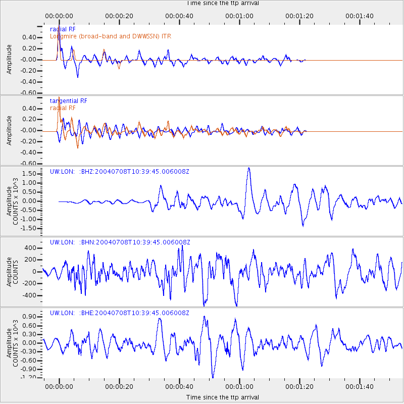
Signal To Noise
| Channel | StoN | STA | LTA |
| UW:LON: :BHN:20040708T10:39:45.006008Z | 2.1432273 | 98.466576 | 45.94313 |
| UW:LON: :BHE:20040708T10:39:45.006008Z | 3.321898 | 228.15921 | 68.68339 |
| UW:LON: :BHZ:20040708T10:39:45.006008Z | 6.6539745 | 404.77124 | 60.8315 |
| Arrivals |
| Ps | 4.3 SECOND |
| PpPs | 15 SECOND |
| PsPs/PpSs | 20 SECOND |


