You are here: Home > Network List > CN - Canadian National Seismograph Network Stations List
> Station INK INUVIK, NT > Earthquake Result Viewer
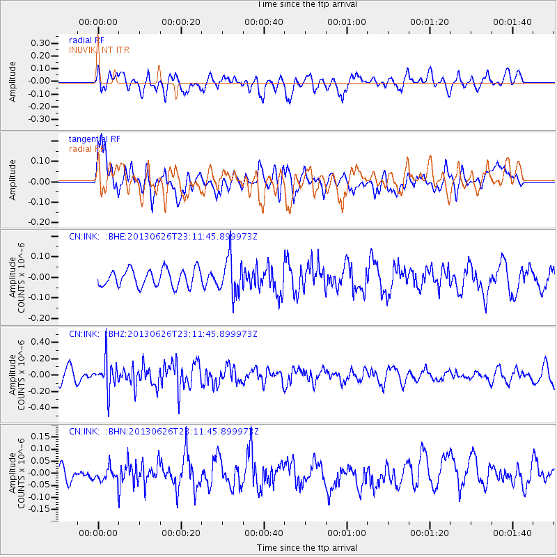
INK INUVIK, NT - Earthquake Result Viewer
*The percent match for this event was below the threshold and hence no stack was calculated.
| Earthquake location: |
Southern Molucca Sea |
| Earthquake latitude/longitude: |
-0.1/125.1 |
| Earthquake time(UTC): |
2013/06/26 (177) 22:59:00 GMT |
| Earthquake Depth: |
33 km |
| Earthquake Magnitude: |
5.5 MW, 5.9 MB |
| Earthquake Catalog/Contributor: |
NEIC PDE/NEIC PDE-W |
|
| Network: |
CN Canadian National Seismograph Network |
| Station: |
INK INUVIK, NT |
| Lat/Lon: |
68.31 N/133.53 W |
| Elevation: |
44 m |
|
| Distance: |
94.4 deg |
| Az: |
21.437 deg |
| Baz: |
280.57 deg |
| Ray Param: |
$rayparam |
*The percent match for this event was below the threshold and hence was not used in the summary stack. |
|
| Radial Match: |
61.97646 % |
| Radial Bump: |
400 |
| Transverse Match: |
59.192863 % |
| Transverse Bump: |
400 |
| SOD ConfigId: |
512894 |
| Insert Time: |
2013-09-15 10:06:58.992 +0000 |
| GWidth: |
2.5 |
| Max Bumps: |
400 |
| Tol: |
0.001 |
|
Signal To Noise
| Channel | StoN | STA | LTA |
| CN:INK: :BHZ:20130626T23:11:45.899973Z | 2.907135 | 1.8705377E-7 | 6.4343E-8 |
| CN:INK: :BHN:20130626T23:11:45.899973Z | 0.5362002 | 2.7644385E-8 | 5.1556082E-8 |
| CN:INK: :BHE:20130626T23:11:45.899973Z | 2.2165403 | 9.136021E-8 | 4.121748E-8 |
| Arrivals |
| Ps | |
| PpPs | |
| PsPs/PpSs | |


