You are here: Home > Network List > TA - USArray Transportable Network (new EarthScope stations) Stations List
> Station U57A Blanch, NC, USA > Earthquake Result Viewer
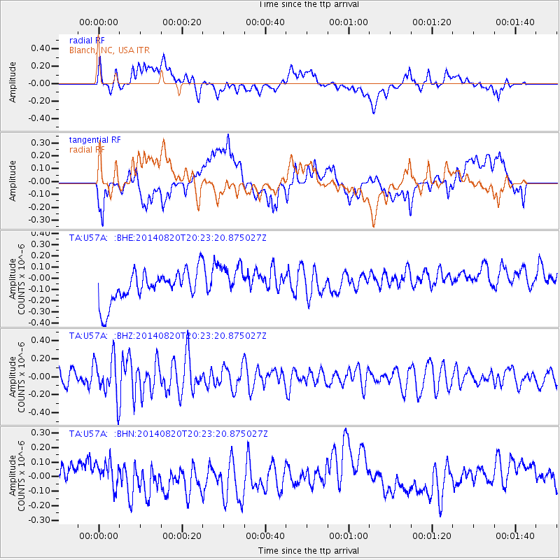
U57A Blanch, NC, USA - Earthquake Result Viewer
*The percent match for this event was below the threshold and hence no stack was calculated.
| Earthquake location: |
Rat Islands, Aleutian Islands |
| Earthquake latitude/longitude: |
52.5/175.4 |
| Earthquake time(UTC): |
2014/08/20 (232) 20:12:38 GMT |
| Earthquake Depth: |
5.2 km |
| Earthquake Magnitude: |
5.6 MW, 5.4 mb, 5.3 Ms_20, 5.5 Mwb, 5.0 ML, 5.6 Mwc |
| Earthquake Catalog/Contributor: |
ISC/ISC |
|
| Network: |
TA USArray Transportable Network (new EarthScope stations) |
| Station: |
U57A Blanch, NC, USA |
| Lat/Lon: |
36.43 N/79.34 W |
| Elevation: |
178 m |
|
| Distance: |
70.2 deg |
| Az: |
55.75 deg |
| Baz: |
321.209 deg |
| Ray Param: |
$rayparam |
*The percent match for this event was below the threshold and hence was not used in the summary stack. |
|
| Radial Match: |
52.724365 % |
| Radial Bump: |
400 |
| Transverse Match: |
46.7103 % |
| Transverse Bump: |
400 |
| SOD ConfigId: |
3390531 |
| Insert Time: |
2019-04-13 12:21:28.865 +0000 |
| GWidth: |
2.5 |
| Max Bumps: |
400 |
| Tol: |
0.001 |
|
Signal To Noise
| Channel | StoN | STA | LTA |
| TA:U57A: :BHZ:20140820T20:23:20.875027Z | 2.2982974 | 2.2007617E-7 | 9.575618E-8 |
| TA:U57A: :BHN:20140820T20:23:20.875027Z | 1.2623299 | 8.414457E-8 | 6.665814E-8 |
| TA:U57A: :BHE:20140820T20:23:20.875027Z | 1.0819061 | 1.501675E-7 | 1.3879901E-7 |
| Arrivals |
| Ps | |
| PpPs | |
| PsPs/PpSs | |


