You are here: Home > Network List > GO - National Seismic Network of Georgia Stations List
> Station AKH Akhalkalaki, Georgia > Earthquake Result Viewer
AKH Akhalkalaki, Georgia - Earthquake Result Viewer
| Earthquake location: |
Halmahera, Indonesia |
| Earthquake latitude/longitude: |
1.1/127.1 |
| Earthquake time(UTC): |
2013/06/27 (178) 08:38:08 GMT |
| Earthquake Depth: |
120 km |
| Earthquake Magnitude: |
5.7 MW, 5.7 MB, 5.7 MW |
| Earthquake Catalog/Contributor: |
NEIC PDE/NEIC PDE-W |
|
| Network: |
GO National Seismic Network of Georgia |
| Station: |
AKH Akhalkalaki, Georgia |
| Lat/Lon: |
41.41 N/43.49 E |
| Elevation: |
1708 m |
|
| Distance: |
84.5 deg |
| Az: |
311.32 deg |
| Baz: |
93.369 deg |
| Ray Param: |
0.045180015 |
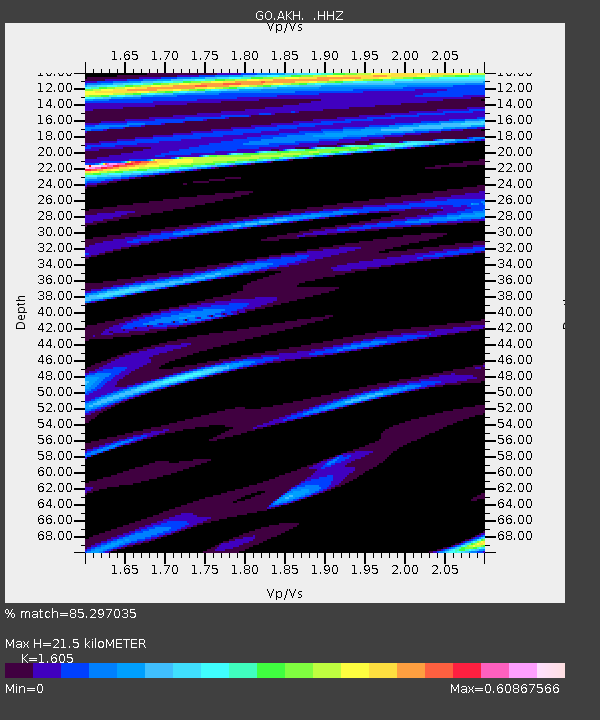
| Estimated Moho Depth: |
21.5 km |
| Estimated Crust Vp/Vs: |
1.61 |
| Assumed Crust Vp: |
6.419 km/s |
| Estimated Crust Vs: |
4.0 km/s |
| Estimated Crust Poisson's Ratio: |
0.18 |
|
| Radial Match: |
85.297035 % |
| Radial Bump: |
400 |
| Transverse Match: |
82.079155 % |
| Transverse Bump: |
400 |
| SOD ConfigId: |
512894 |
| Insert Time: |
2013-09-15 10:18:14.856 +0000 |
| GWidth: |
2.5 |
| Max Bumps: |
400 |
| Tol: |
0.001 |
|

Signal To Noise
| Channel | StoN | STA | LTA |
| GO:AKH: :HHZ:20130627T08:49:56.580029Z | 18.105204 | 9.61655E-7 | 5.3114842E-8 |
| GO:AKH: :HHN:20130627T08:49:56.580029Z | 0.70085907 | 5.250709E-8 | 7.4918184E-8 |
| GO:AKH: :HHE:20130627T08:49:56.580029Z | 4.1967273 | 2.0823443E-7 | 4.9618286E-8 |
| Arrivals |
| Ps | 2.1 SECOND |
| PpPs | 8.5 SECOND |
| PsPs/PpSs | 11 SECOND |


