You are here: Home > Network List > US - United States National Seismic Network Stations List
> Station EGMT Eagleton, Montana, USA > Earthquake Result Viewer
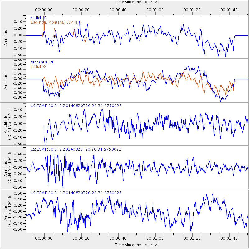
EGMT Eagleton, Montana, USA - Earthquake Result Viewer
*The percent match for this event was below the threshold and hence no stack was calculated.
| Earthquake location: |
Rat Islands, Aleutian Islands |
| Earthquake latitude/longitude: |
52.5/175.4 |
| Earthquake time(UTC): |
2014/08/20 (232) 20:12:38 GMT |
| Earthquake Depth: |
5.2 km |
| Earthquake Magnitude: |
5.6 MW, 5.4 mb, 5.3 Ms_20, 5.5 Mwb, 5.0 ML, 5.6 Mwc |
| Earthquake Catalog/Contributor: |
ISC/ISC |
|
| Network: |
US United States National Seismic Network |
| Station: |
EGMT Eagleton, Montana, USA |
| Lat/Lon: |
48.02 N/109.75 W |
| Elevation: |
1055 m |
|
| Distance: |
46.1 deg |
| Az: |
64.123 deg |
| Baz: |
304.992 deg |
| Ray Param: |
$rayparam |
*The percent match for this event was below the threshold and hence was not used in the summary stack. |
|
| Radial Match: |
59.760235 % |
| Radial Bump: |
400 |
| Transverse Match: |
59.32437 % |
| Transverse Bump: |
400 |
| SOD ConfigId: |
3390531 |
| Insert Time: |
2019-04-13 12:22:13.876 +0000 |
| GWidth: |
2.5 |
| Max Bumps: |
400 |
| Tol: |
0.001 |
|
Signal To Noise
| Channel | StoN | STA | LTA |
| US:EGMT:00:BHZ:20140820T20:20:31.975002Z | 3.0101655 | 2.0486469E-7 | 6.8057616E-8 |
| US:EGMT:00:BH1:20140820T20:20:31.975002Z | 2.496885 | 4.117699E-7 | 1.6491344E-7 |
| US:EGMT:00:BH2:20140820T20:20:31.975002Z | 1.1987901 | 2.608177E-7 | 2.1756745E-7 |
| Arrivals |
| Ps | |
| PpPs | |
| PsPs/PpSs | |


