You are here: Home > Network List > TJ - Tajikistan National Seismic Network Stations List
> Station GARM Garm, Tajikistan > Earthquake Result Viewer
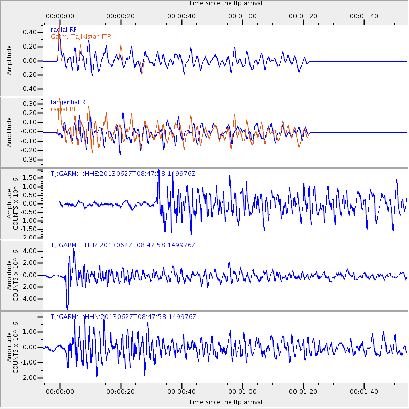
GARM Garm, Tajikistan - Earthquake Result Viewer
*The percent match for this event was below the threshold and hence no stack was calculated.
| Earthquake location: |
Halmahera, Indonesia |
| Earthquake latitude/longitude: |
1.1/127.1 |
| Earthquake time(UTC): |
2013/06/27 (178) 08:38:08 GMT |
| Earthquake Depth: |
120 km |
| Earthquake Magnitude: |
5.7 MW, 5.7 MB, 5.7 MW |
| Earthquake Catalog/Contributor: |
NEIC PDE/NEIC PDE-W |
|
| Network: |
TJ Tajikistan National Seismic Network |
| Station: |
GARM Garm, Tajikistan |
| Lat/Lon: |
39.00 N/70.32 E |
| Elevation: |
1305 m |
|
| Distance: |
64.0 deg |
| Az: |
313.48 deg |
| Baz: |
111.402 deg |
| Ray Param: |
$rayparam |
*The percent match for this event was below the threshold and hence was not used in the summary stack. |
|
| Radial Match: |
77.17922 % |
| Radial Bump: |
400 |
| Transverse Match: |
77.30363 % |
| Transverse Bump: |
400 |
| SOD ConfigId: |
512894 |
| Insert Time: |
2013-09-15 10:24:24.070 +0000 |
| GWidth: |
2.5 |
| Max Bumps: |
400 |
| Tol: |
0.001 |
|
Signal To Noise
| Channel | StoN | STA | LTA |
| TJ:GARM: :HHZ:20130627T08:47:58.149976Z | 31.711205 | 2.1124665E-6 | 6.661577E-8 |
| TJ:GARM: :HHN:20130627T08:47:58.149976Z | 3.4688551 | 4.396138E-7 | 1.2673168E-7 |
| TJ:GARM: :HHE:20130627T08:47:58.149976Z | 6.8282094 | 7.019221E-7 | 1.0279739E-7 |
| Arrivals |
| Ps | |
| PpPs | |
| PsPs/PpSs | |


