You are here: Home > Network List > UW - Pacific Northwest Regional Seismic Network Stations List
> Station FISH Seaside, OR, USA > Earthquake Result Viewer
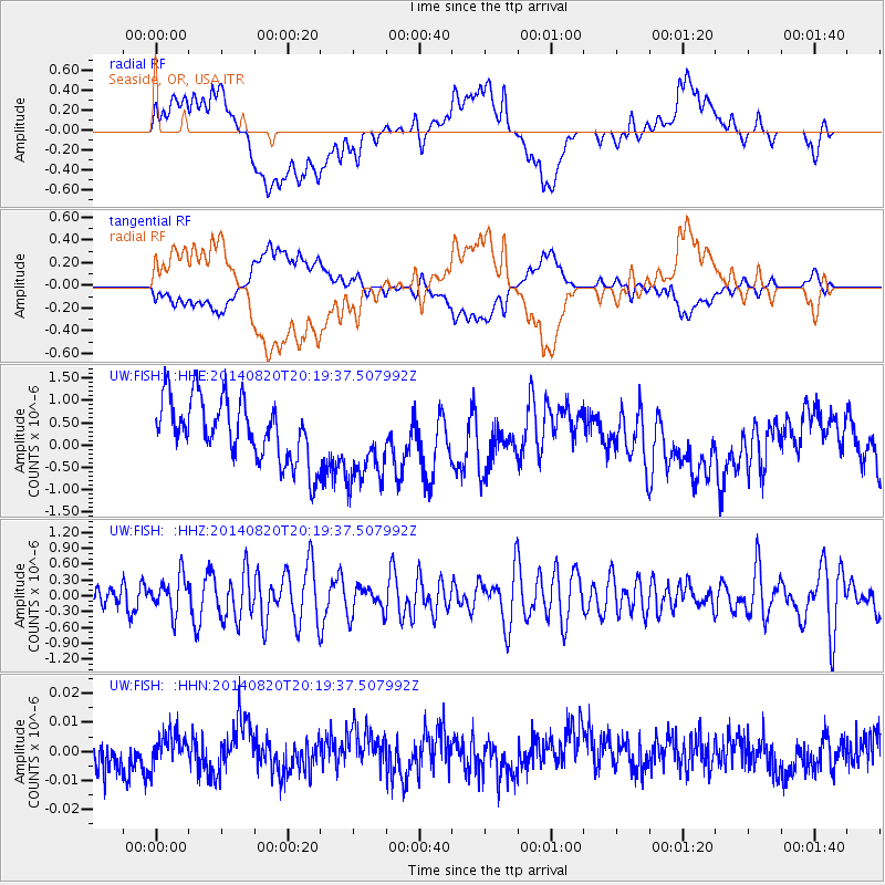
FISH Seaside, OR, USA - Earthquake Result Viewer
*The percent match for this event was below the threshold and hence no stack was calculated.
| Earthquake location: |
Rat Islands, Aleutian Islands |
| Earthquake latitude/longitude: |
52.5/175.4 |
| Earthquake time(UTC): |
2014/08/20 (232) 20:12:38 GMT |
| Earthquake Depth: |
5.2 km |
| Earthquake Magnitude: |
5.6 MW, 5.4 mb, 5.3 Ms_20, 5.5 Mwb, 5.0 ML, 5.6 Mwc |
| Earthquake Catalog/Contributor: |
ISC/ISC |
|
| Network: |
UW Pacific Northwest Regional Seismic Network |
| Station: |
FISH Seaside, OR, USA |
| Lat/Lon: |
45.93 N/123.56 W |
| Elevation: |
325 m |
|
| Distance: |
39.4 deg |
| Az: |
74.406 deg |
| Baz: |
302.485 deg |
| Ray Param: |
$rayparam |
*The percent match for this event was below the threshold and hence was not used in the summary stack. |
|
| Radial Match: |
30.828386 % |
| Radial Bump: |
400 |
| Transverse Match: |
30.57895 % |
| Transverse Bump: |
400 |
| SOD ConfigId: |
3390531 |
| Insert Time: |
2019-04-13 12:22:37.383 +0000 |
| GWidth: |
2.5 |
| Max Bumps: |
400 |
| Tol: |
0.001 |
|
Signal To Noise
| Channel | StoN | STA | LTA |
| UW:FISH: :HHZ:20140820T20:19:37.507992Z | 1.4354062 | 3.4800135E-7 | 2.4244102E-7 |
| UW:FISH: :HHN:20140820T20:19:37.507992Z | 1.0171185 | 5.2223075E-9 | 5.1344142E-9 |
| UW:FISH: :HHE:20140820T20:19:37.507992Z | 1.3809376 | 9.405177E-7 | 6.810718E-7 |
| Arrivals |
| Ps | |
| PpPs | |
| PsPs/PpSs | |


