You are here: Home > Network List > CN - Canadian National Seismograph Network Stations List
> Station INK INUVIK, NT > Earthquake Result Viewer
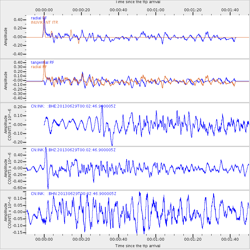
INK INUVIK, NT - Earthquake Result Viewer
*The percent match for this event was below the threshold and hence no stack was calculated.
| Earthquake location: |
Taiwan Region |
| Earthquake latitude/longitude: |
24.1/122.2 |
| Earthquake time(UTC): |
2013/06/28 (179) 23:51:49 GMT |
| Earthquake Depth: |
15 km |
| Earthquake Magnitude: |
5.7 MW, 5.5 MW, 5.5 MS, 5.6 MB |
| Earthquake Catalog/Contributor: |
NEIC PDE/NEIC PDE-W |
|
| Network: |
CN Canadian National Seismograph Network |
| Station: |
INK INUVIK, NT |
| Lat/Lon: |
68.31 N/133.53 W |
| Elevation: |
44 m |
|
| Distance: |
73.0 deg |
| Az: |
22.143 deg |
| Baz: |
292.097 deg |
| Ray Param: |
$rayparam |
*The percent match for this event was below the threshold and hence was not used in the summary stack. |
|
| Radial Match: |
74.02963 % |
| Radial Bump: |
400 |
| Transverse Match: |
57.137024 % |
| Transverse Bump: |
400 |
| SOD ConfigId: |
512894 |
| Insert Time: |
2013-09-15 10:33:54.903 +0000 |
| GWidth: |
2.5 |
| Max Bumps: |
400 |
| Tol: |
0.001 |
|
Signal To Noise
| Channel | StoN | STA | LTA |
| CN:INK: :BHZ:20130629T00:02:46.900005Z | 7.473791 | 2.99034E-7 | 4.001102E-8 |
| CN:INK: :BHN:20130629T00:02:46.900005Z | 1.2442683 | 5.4944778E-8 | 4.4158302E-8 |
| CN:INK: :BHE:20130629T00:02:46.900005Z | 2.1752112 | 9.4400974E-8 | 4.3398533E-8 |
| Arrivals |
| Ps | |
| PpPs | |
| PsPs/PpSs | |


