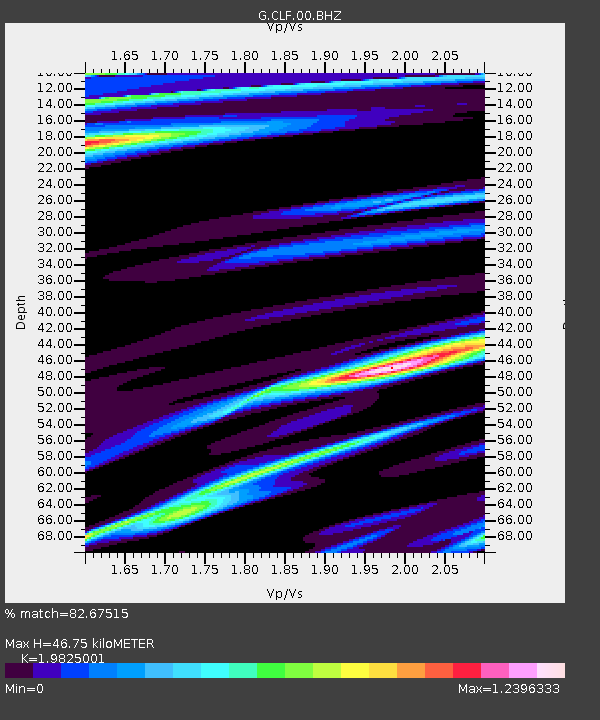
CLF Chambon la Foret observatory, France - Earthquake Result Viewer

Earthquake location: Northern Sumatra, Indonesia
Earthquake latitude/longitude: 4.6/96.7
Earthquake time(UTC): 2013/07/02 (183) 07:37:02 GMT
Earthquake Depth: 13 km
Earthquake Magnitude: 6.1 MW, 5.9 MB, 6.1 MW, 6.2 MS
Earthquake Catalog/Contributor: NEIC PDE/NEIC PDE-W
Network: G GEOSCOPE
Station: CLF Chambon la Foret observatory, France
Lat/Lon: 48.03 N/2.26 E
Elevation: 145 m
Distance: 89.5 deg
Az: 317.986 deg
Baz: 83.642 deg
Ray Param: 0.041779377
Estimated Moho Depth: 46.75 km
Estimated Crust Vp/Vs: 1.98
Assumed Crust Vp: 6.12 km/s
Estimated Crust Vs: 3.087 km/s
Estimated Crust Poisson's Ratio: 0.33
Radial Match: 82.67515 %
Radial Bump: 400
Transverse Match: 73.51109 %
Transverse Bump: 400
SOD ConfigId: 512894
Insert Time: 2013-09-15 10:57:42.629 +0000
GWidth: 2.5
Max Bumps: 400
Tol: 0.001

Signal To Noise

ChannelStoNSTALTA
G:CLF:00:BHZ:20130702T07:49:27.950027Z3.9383826.745116E-71.7126618E-7
G:CLF:00:BHN:20130702T07:49:27.950027Z0.66060171.8209037E-72.7564323E-7
G:CLF:00:BHE:20130702T07:49:27.950027Z2.20186574.7096964E-72.1389572E-7
Arrivals
Ps7.6 SECOND
PpPs22 SECOND
PsPs/PpSs30 SECOND