You are here: Home > Network List > II - Global Seismograph Network (GSN - IRIS/IDA) Stations List
> Station WRAB Tennant Creek, NT, Australia > Earthquake Result Viewer
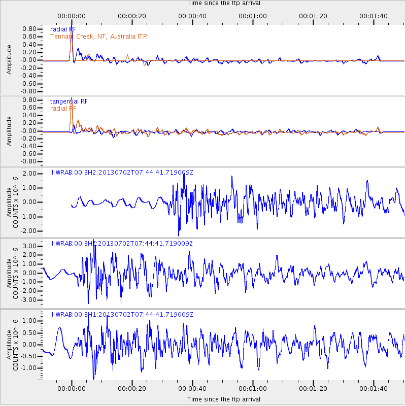
WRAB Tennant Creek, NT, Australia - Earthquake Result Viewer
*The percent match for this event was below the threshold and hence no stack was calculated.
| Earthquake location: |
Northern Sumatra, Indonesia |
| Earthquake latitude/longitude: |
4.6/96.7 |
| Earthquake time(UTC): |
2013/07/02 (183) 07:37:02 GMT |
| Earthquake Depth: |
13 km |
| Earthquake Magnitude: |
6.1 MW, 5.9 MB, 6.1 MW, 6.2 MS |
| Earthquake Catalog/Contributor: |
NEIC PDE/NEIC PDE-W |
|
| Network: |
II Global Seismograph Network (GSN - IRIS/IDA) |
| Station: |
WRAB Tennant Creek, NT, Australia |
| Lat/Lon: |
19.93 S/134.36 E |
| Elevation: |
366 m |
|
| Distance: |
44.4 deg |
| Az: |
124.657 deg |
| Baz: |
299.369 deg |
| Ray Param: |
$rayparam |
*The percent match for this event was below the threshold and hence was not used in the summary stack. |
|
| Radial Match: |
77.97653 % |
| Radial Bump: |
400 |
| Transverse Match: |
56.313416 % |
| Transverse Bump: |
400 |
| SOD ConfigId: |
512894 |
| Insert Time: |
2013-09-15 11:00:24.647 +0000 |
| GWidth: |
2.5 |
| Max Bumps: |
400 |
| Tol: |
0.001 |
|
Signal To Noise
| Channel | StoN | STA | LTA |
| II:WRAB:00:BHZ:20130702T07:44:41.719009Z | 1.9964715 | 6.3677834E-7 | 3.189519E-7 |
| II:WRAB:00:BH1:20130702T07:44:41.719009Z | 1.1800452 | 3.3564964E-7 | 2.8443793E-7 |
| II:WRAB:00:BH2:20130702T07:44:41.719009Z | 2.243761 | 4.3443762E-7 | 1.9362028E-7 |
| Arrivals |
| Ps | |
| PpPs | |
| PsPs/PpSs | |


