You are here: Home > Network List > IU - Global Seismograph Network (GSN - IRIS/USGS) Stations List
> Station CTAO Charters Towers, Australia > Earthquake Result Viewer
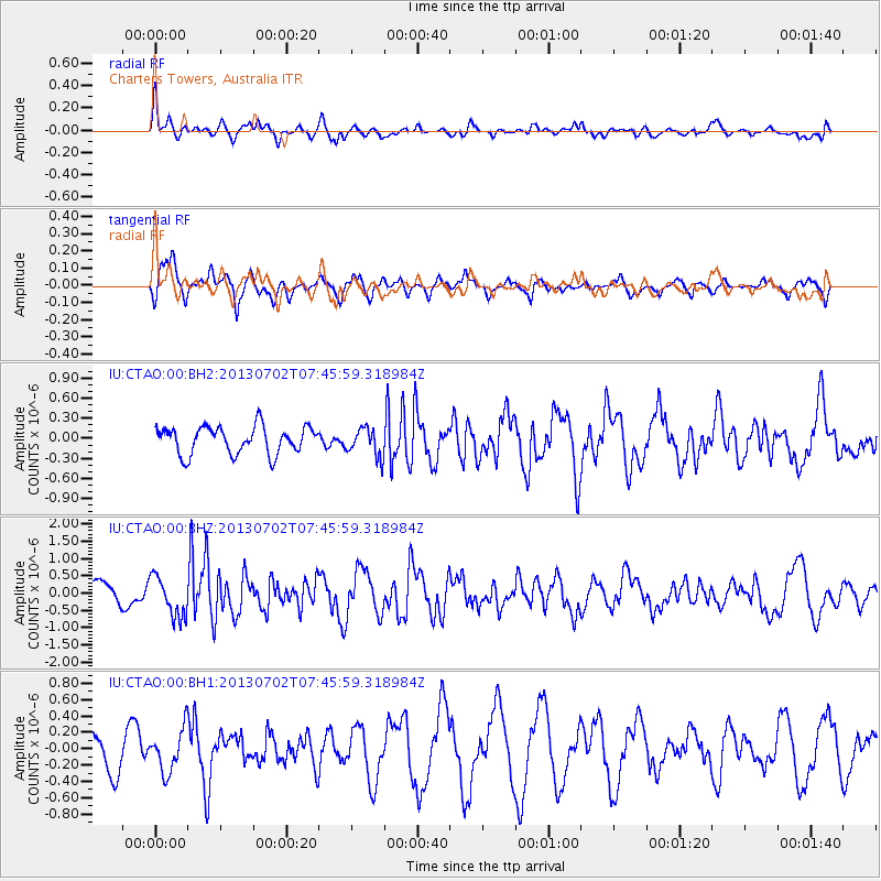
CTAO Charters Towers, Australia - Earthquake Result Viewer
*The percent match for this event was below the threshold and hence no stack was calculated.
| Earthquake location: |
Northern Sumatra, Indonesia |
| Earthquake latitude/longitude: |
4.6/96.7 |
| Earthquake time(UTC): |
2013/07/02 (183) 07:37:02 GMT |
| Earthquake Depth: |
13 km |
| Earthquake Magnitude: |
6.1 MW, 5.9 MB, 6.1 MW, 6.2 MS |
| Earthquake Catalog/Contributor: |
NEIC PDE/NEIC PDE-W |
|
| Network: |
IU Global Seismograph Network (GSN - IRIS/USGS) |
| Station: |
CTAO Charters Towers, Australia |
| Lat/Lon: |
20.09 S/146.25 E |
| Elevation: |
357 m |
|
| Distance: |
54.6 deg |
| Az: |
118.548 deg |
| Baz: |
291.321 deg |
| Ray Param: |
$rayparam |
*The percent match for this event was below the threshold and hence was not used in the summary stack. |
|
| Radial Match: |
73.19613 % |
| Radial Bump: |
375 |
| Transverse Match: |
67.15882 % |
| Transverse Bump: |
377 |
| SOD ConfigId: |
512894 |
| Insert Time: |
2013-09-15 11:00:44.850 +0000 |
| GWidth: |
2.5 |
| Max Bumps: |
400 |
| Tol: |
0.001 |
|
Signal To Noise
| Channel | StoN | STA | LTA |
| IU:CTAO:00:BHZ:20130702T07:45:59.318984Z | 2.0499265 | 5.8558237E-7 | 2.8566015E-7 |
| IU:CTAO:00:BH1:20130702T07:45:59.318984Z | 1.3029176 | 2.5803885E-7 | 1.9804695E-7 |
| IU:CTAO:00:BH2:20130702T07:45:59.318984Z | 1.0317321 | 2.109713E-7 | 2.0448263E-7 |
| Arrivals |
| Ps | |
| PpPs | |
| PsPs/PpSs | |


