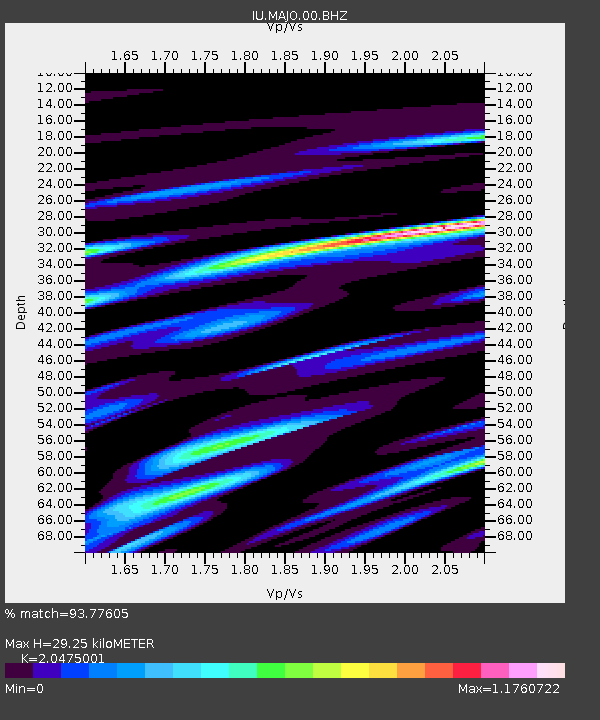
MAJO Matsushiro, Japan - Earthquake Result Viewer
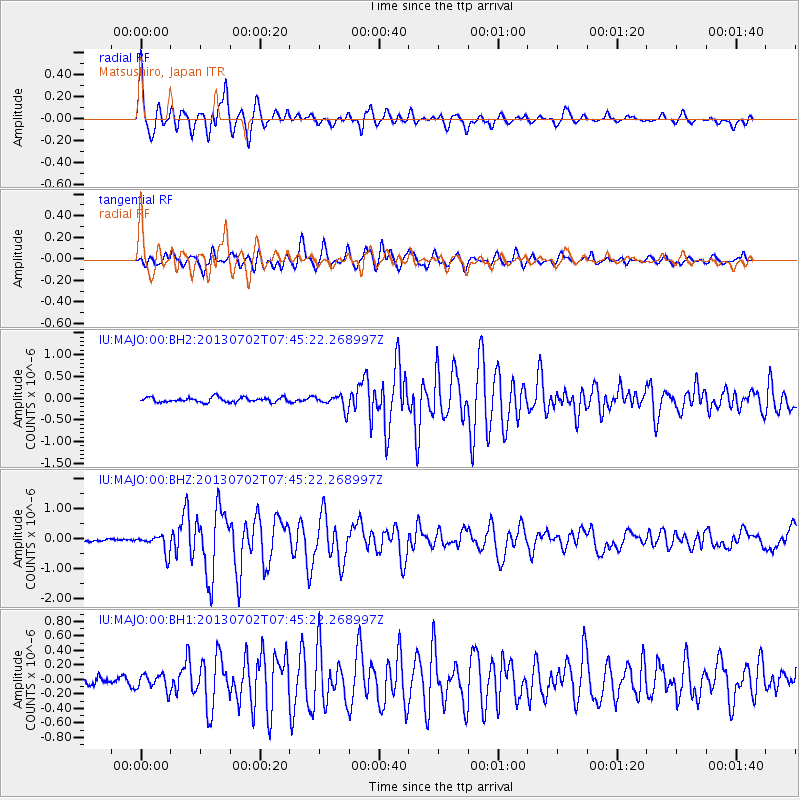
Earthquake location: Northern Sumatra, Indonesia
Earthquake latitude/longitude: 4.6/96.7
Earthquake time(UTC): 2013/07/02 (183) 07:37:02 GMT
Earthquake Depth: 13 km
Earthquake Magnitude: 6.1 MW, 5.9 MB, 6.1 MW, 6.2 MS
Earthquake Catalog/Contributor: NEIC PDE/NEIC PDE-W
Network: IU Global Seismograph Network (GSN - IRIS/USGS)
Station: MAJO Matsushiro, Japan
Lat/Lon: 36.55 N/138.20 E
Elevation: 405 m
Distance: 49.6 deg
Az: 44.55 deg
Baz: 240.265 deg
Ray Param: 0.068608224
Estimated Moho Depth: 29.25 km
Estimated Crust Vp/Vs: 2.05
Assumed Crust Vp: 6.461 km/s
Estimated Crust Vs: 3.156 km/s
Estimated Crust Poisson's Ratio: 0.34
Radial Match: 93.77605 %
Radial Bump: 400
Transverse Match: 86.3986 %
Transverse Bump: 400
SOD ConfigId: 512894
Insert Time: 2013-09-15 11:01:08.424 +0000
GWidth: 2.5
Max Bumps: 400
Tol: 0.001

Signal To Noise

ChannelStoNSTALTA
IU:MAJO:00:BHZ:20130702T07:45:22.268997Z7.679213.074798E-74.0040554E-8
IU:MAJO:00:BH1:20130702T07:45:22.268997Z2.3086691.1216719E-74.858522E-8
IU:MAJO:00:BH2:20130702T07:45:22.268997Z3.0622831.6555943E-75.4064053E-8
Arrivals
Ps5.0 SECOND
PpPs13 SECOND
PsPs/PpSs18 SECOND