You are here: Home > Network List > UW - Pacific Northwest Regional Seismic Network Stations List
> Station LON Longmire (broad-band and DWWSSN) > Earthquake Result Viewer
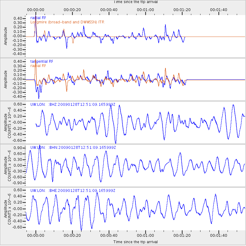
LON Longmire (broad-band and DWWSSN) - Earthquake Result Viewer
*The percent match for this event was below the threshold and hence no stack was calculated.
| Earthquake location: |
Samoa Islands Region |
| Earthquake latitude/longitude: |
-17.0/-172.1 |
| Earthquake time(UTC): |
2009/01/28 (028) 12:39:42 GMT |
| Earthquake Depth: |
10 km |
| Earthquake Magnitude: |
5.6 MB, 5.3 MS, 5.5 MW |
| Earthquake Catalog/Contributor: |
WHDF/NEIC |
|
| Network: |
UW Pacific Northwest Regional Seismic Network |
| Station: |
LON Longmire (broad-band and DWWSSN) |
| Lat/Lon: |
46.75 N/121.81 W |
| Elevation: |
850 m |
|
| Distance: |
77.9 deg |
| Az: |
32.738 deg |
| Baz: |
228.82 deg |
| Ray Param: |
$rayparam |
*The percent match for this event was below the threshold and hence was not used in the summary stack. |
|
| Radial Match: |
64.32248 % |
| Radial Bump: |
298 |
| Transverse Match: |
71.606316 % |
| Transverse Bump: |
400 |
| SOD ConfigId: |
2658 |
| Insert Time: |
2010-02-27 04:47:21.856 +0000 |
| GWidth: |
2.5 |
| Max Bumps: |
400 |
| Tol: |
0.001 |
|
Signal To Noise
| Channel | StoN | STA | LTA |
| UW:LON: :BHN:20090128T12:51:09.165999Z | 1.8818598 | 5.5163383E-7 | 2.9313227E-7 |
| UW:LON: :BHE:20090128T12:51:09.165999Z | 1.3873522 | 2.6686732E-7 | 1.923573E-7 |
| UW:LON: :BHZ:20090128T12:51:09.165999Z | 1.0514817 | 1.7733784E-7 | 1.6865518E-7 |
| Arrivals |
| Ps | |
| PpPs | |
| PsPs/PpSs | |


